Al Qiţena night lights from space
Night Light of Al Qiţena (White Nile) from space (Sudan) Src. Average luminocity for 10x10km area is 2.969% and for 50x50km: 0.1457%.
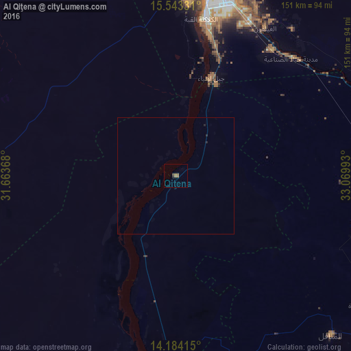
Analysis of Al Qiţena night lights 2016
Square area 10x10 km:
 0%
0%90-99
0%80-89
0%70-79
0%60-69
2.48%50-59
0.83%40-49
0.83%30-39
0.21%20-29
0.62%10-19
0%0-9
95.04%Square area 50x50 km:
0%90-99
0%80-89
0%70-79
0%60-69
0.1%50-59
0.03%40-49
0.03%30-39
0.01%20-29
0.12%10-19
0%0-9
99.7%Clear (daylight) street map image can be seen on geolist.org.
Map coordinates:
15° 32' 35.9" North, 31° 39' 49.2" East
14° 51' 53.3" North, 32° 22' 0.5" East
14° 11' 2.9" North, 33° 4' 11.7" East
Some cities around Al Qiţena sort by population:
• Khartoum
78.4 km =48.7 mi,  13°
13°
• Omdurman
87.5 km =54.4 mi, 7°
• Al Manāqil
96 km =59.7 mi,  135°
135°
• Ad Douiem
96.2 km =59.8 mi,  183°
183°
• Al Hilāliyya
93.6 km =58.2 mi,  84°
84°
• Wad Rāwah
89.3 km =55.5 mi,  68°
68°
• Al Kiremit al ‘Arakiyyīn
84.6 km =52.6 mi,  132°
132°
• Wad az Zāki
48 km =29.8 mi,  201°
201°
379014 (p: 18,321)
Sources (retrieved 2019-11-25):
» Earth at Night: Flat Maps 2012, 2016