Al Kiremit al ‘Arakiyyīn night lights from space
Night Light of Al Kiremit al ‘Arakiyyīn (Al Jazīrah) from space (Sudan) Src. Average luminocity for 10x10km area is 0.2814% and for 50x50km: 0.3315%.
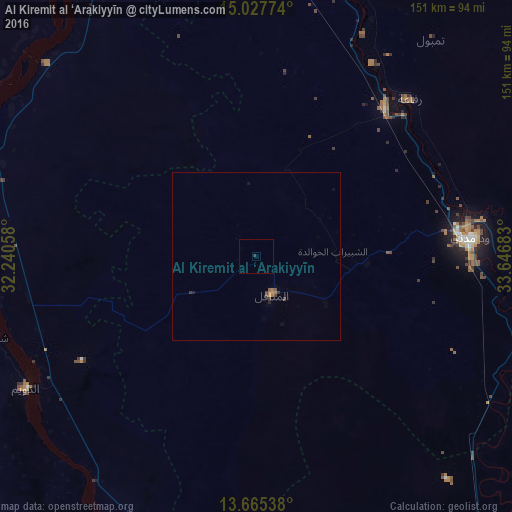
Analysis of Al Kiremit al ‘Arakiyyīn night lights 2016
Square area 10x10 km:
 0%
0%90-99
0%80-89
0%70-79
0%60-69
0%50-59
0%40-49
0%30-39
0.87%20-29
0%10-19
0%0-9
99.13%Square area 50x50 km:
0%90-99
0%80-89
0%70-79
0.06%60-69
0.14%50-59
0.03%40-49
0.13%30-39
0.17%20-29
0.04%10-19
0.08%0-9
99.35%Clear (daylight) street map image can be seen on geolist.org.
Map coordinates:
15° 1' 39.9" North, 32° 14' 26.1" East
14° 20' 51.4" North, 32° 56' 37.3" East
13° 39' 55.4" North, 33° 38' 48.6" East
Some cities around Al Kiremit al ‘Arakiyyīn sort by population:
• Wad Medani
62.3 km =38.7 mi,  84°
84°
• Al Manāqil
12.3 km =7.6 mi,  156°
156°
• Ad Douiem
78.3 km =48.7 mi,  240°
240°
• Al Hasaheisa
59 km =36.7 mi,  40°
40°
• Kināna
42.4 km =26.3 mi,  144°
144°
• Al Hilāliyya
72.9 km =45.3 mi,  25°
25°
• Al Masallamiyya
49.3 km =30.6 mi,  59°
59°
• Wad az Zāki
80.4 km =50 mi,  279°
279°
379261 (p: 9,775)
Sources (retrieved 2019-11-25):
» Earth at Night: Flat Maps 2012, 2016