Tumayr night lights from space
Night Light of Tumayr (Ar Riyāḑ) from space (Saudi Arabia) Src. Average luminocity for 10x10km area is 47.0095% and for 50x50km: 10.6921%.
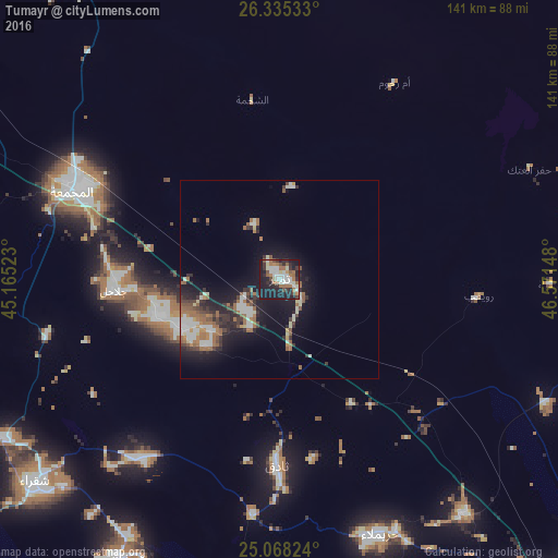
Analysis of Tumayr night lights 2016
Square area 10x10 km:
 7.58%
7.58%90-99
12.88%80-89
3.03%70-79
1.89%60-69
11.74%50-59
4.92%40-49
5.49%30-39
6.44%20-29
14.77%10-19
31.25%0-9
0%Square area 50x50 km:
1.13%90-99
2.39%80-89
0.66%70-79
0.42%60-69
2.57%50-59
1.65%40-49
1.11%30-39
1.79%20-29
3.09%10-19
8.67%0-9
76.52%Clear (daylight) street map image can be seen on geolist.org.
Map coordinates:
26° 20' 7.2" North, 45° 9' 54.8" East
25° 42' 12.5" North, 45° 52' 6.1" East
25° 4' 5.7" North, 46° 34' 17.3" East
Some cities around Tumayr sort by population:
• Riyadh
141.9 km =88.2 mi,  142°
142°
• Buraydah
201.5 km =125.2 mi,  290°
290°
• Al Mithnab
165.7 km =103 mi,  276°
276°
• Ad Dawādimī
199.4 km =123.9 mi,  228°
228°
• Az Zulfī
124.4 km =77.3 mi,  302°
302°
• Sājir
139.9 km =86.9 mi,  245°
245°
• Al Arţāwīyah
103 km =64 mi,  329°
329°
• Marāt
81.6 km =50.7 mi,  210°
210°
396550 (p: 8,246)
Sources (retrieved 2019-11-25):
» Earth at Night: Flat Maps 2012, 2016