Al Arţāwīyah night lights from space
Night Light of Al Arţāwīyah (Ar Riyāḑ) from space (Saudi Arabia) Src. Average luminocity for 10x10km area is 48.553% and for 50x50km: 5.6942%.
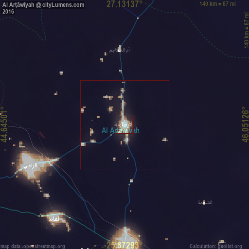
Analysis of Al Arţāwīyah night lights 2016
Square area 10x10 km:
 11.55%
90-99
8.9%80-89
3.79%70-79
2.65%60-69
12.12%50-59
6.44%40-49
2.08%30-39
11.17%20-29
12.69%10-19
28.03%0-9
0.57%Square area 50x50 km:
0.65%90-99
1.06%80-89
0.5%70-79
0.42%60-69
1.07%50-59
0.79%40-49
0.39%30-39
0.96%20-29
1.2%10-19
4.31%0-9
88.63%Clear (daylight) street map image can be seen on geolist.org.
Map coordinates:
27° 7' 52.9" North, 44° 38' 42" East
26° 30' 13.9" North, 45° 20' 53.3" East
25° 52' 22.5" North, 46° 3' 4.5" East
Some cities around Al Arţāwīyah sort by population:
• Buraydah
138.2 km =85.9 mi,  261°
261°
• Al Mithnab
133.2 km =82.8 mi,  237°
237°
• Az Zulfī
57.7 km =35.9 mi,  246°
246°
• Al Bukayrīyah
173.3 km =107.7 mi, 256°
• Tanūmah
137.6 km =85.5 mi,  298°
298°
• Sājir
164.9 km =102.5 mi,  207°
207°
• Marāt
159.7 km =99.2 mi,  176°
176°
• Tumayr
103 km =64 mi,  149°
149°
110031 (p: 9,152)
Sources (retrieved 2019-11-25):
» Earth at Night: Flat Maps 2012, 2016