As Sulayyil night lights from space
Night Light of As Sulayyil (Ar Riyāḑ) from space (Saudi Arabia) Src. Average luminocity for 10x10km area is 61.1117% and for 50x50km: 8.0456%.
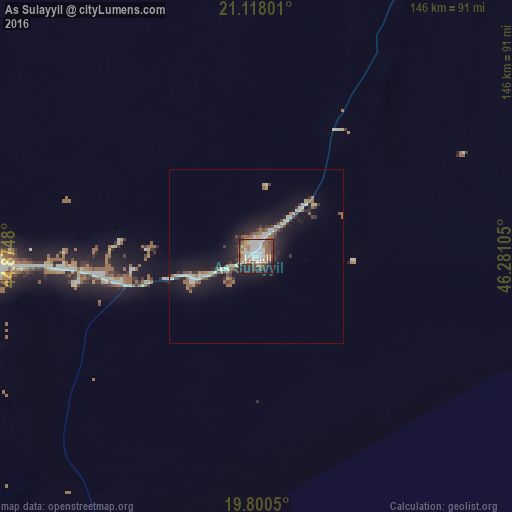

Analysis of As Sulayyil night lights 2016
Square area 10x10 km:
 15.15%
90-99
16.29%80-89
1.89%70-79
5.68%60-69
11.74%50-59
12.88%40-49
6.25%30-39
8.71%20-29
8.71%10-19
12.12%0-9
0.57%Square area 50x50 km:
1.33%90-99
1.33%80-89
0.47%70-79
0.51%60-69
1.01%50-59
1.68%40-49
0.72%30-39
1.34%20-29
2.16%10-19
7.94%0-9
81.53%Clear (daylight) street map image can be seen on geolist.org.
Map coordinates:
21° 7' 4.8" North, 44° 52' 29.3" East
20° 27' 38.4" North, 45° 34' 40.5" East
19° 48' 1.8" North, 46° 16' 51.8" East
Some cities around As Sulayyil sort by population:
• Khamis Mushait
383 km =238 mi,  231°
231°
• Najrān
363.5 km =225.9 mi,  204°
204°
• Abha
407.6 km =253.3 mi, 232°
• Qal‘at Bīshah
314.3 km =195.3 mi,  260°
260°
• An Nimāş
390.2 km =242.5 mi,  247°
247°
• Turabah
418.4 km =260 mi,  281°
281°
• Al Majāridah
411.4 km =255.6 mi, 248°
• Tabālah
336.4 km =209 mi, 260°
108048 (p: 24,097)
Sources (retrieved 2019-11-25):
» Earth at Night: Flat Maps 2012, 2016