Al Majāridah night lights from space
Night Light of Al Majāridah ('Asir) from space (Saudi Arabia) Src. Average luminocity for 10x10km area is 88.6818% and for 50x50km: 39.6731%.
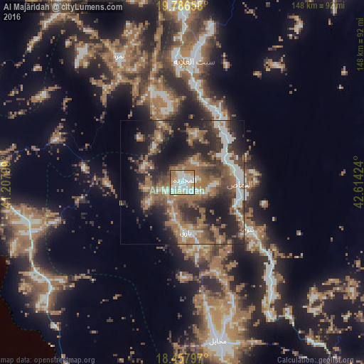
Analysis of Al Majāridah night lights 2016
Square area 10x10 km:
 33.12%
90-99
29.65%80-89
9.74%70-79
11.47%60-69
12.34%50-59
3.25%40-49
0.43%30-39
0%20-29
0%10-19
0%0-9
0%Square area 50x50 km:
5.23%90-99
6.24%80-89
2.24%70-79
3.37%60-69
11.77%50-59
8.39%40-49
6.71%30-39
8.92%20-29
13.17%10-19
15.44%0-9
18.52%Clear (daylight) street map image can be seen on geolist.org.
Map coordinates:
19° 47' 11.7" North, 41° 12' 28.8" East
19° 7' 25" North, 41° 54' 40" East
18° 27' 28.7" North, 42° 36' 51.3" East
Some cities around Al Majāridah sort by population:
• Khamis Mushait
126 km =78.3 mi,  136°
136°
• Abha
118.7 km =73.8 mi,  148°
148°
• Al Bahah
109.2 km =67.9 mi,  334°
334°
• Qal‘at Bīshah
121.6 km =75.6 mi,  36°
36°
• An Nimāş
22.1 km =13.7 mi,  83°
83°
• Al Mindak
132.6 km =82.4 mi, 330°
• Ad Darb
159.9 km =99.4 mi,  166°
166°
• Tabālah
105.2 km =65.4 mi,  29°
29°
399518 (p: 14,830)
Sources (retrieved 2019-11-25):
» Earth at Night: Flat Maps 2012, 2016