Al Bukayrīyah night lights from space
Night Light of Al Bukayrīyah (Al-Qassim) from space (Saudi Arabia) Src. Average luminocity for 10x10km area is 91.1528% and for 50x50km: 44.2459%.
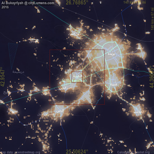
Analysis of Al Bukayrīyah night lights 2016
Square area 10x10 km:
 32.34%
90-99
35.12%80-89
11.31%70-79
13.29%60-69
7.94%50-59
0%40-49
0%30-39
0%20-29
0%10-19
0%0-9
0%Square area 50x50 km:
7.69%90-99
8.11%80-89
3.43%70-79
4.96%60-69
13.75%50-59
5.88%40-49
7.12%30-39
8.42%20-29
8.08%10-19
12.04%0-9
20.51%Clear (daylight) street map image can be seen on geolist.org.
Map coordinates:
26° 46' 7.1" North, 42° 57' 16.9" East
26° 8' 20.9" North, 43° 39' 28.2" East
25° 30' 22.5" North, 44° 21' 39.4" East
Some cities around Al Bukayrīyah sort by population:
• Buraydah
37.8 km =23.5 mi,  56°
56°
• Ar Rass
34 km =21.1 mi,  208°
208°
• Al Mithnab
64.4 km =40 mi,  118°
118°
• Az Zulfī
116.8 km =72.6 mi,  81°
81°
• Adh Dhibiyah
51.5 km =32 mi,  256°
256°
• Tanūmah
116.8 km =72.6 mi,  23°
23°
• Sājir
142.2 km =88.4 mi,  138°
138°
• Al Fuwayliq
52.8 km =32.8 mi,  309°
309°
109878 (p: 25,153)
Sources (retrieved 2019-11-25):
» Earth at Night: Flat Maps 2012, 2016