Tanūmah night lights from space
Night Light of Tanūmah (Al-Qassim) from space (Saudi Arabia) Src. Average luminocity for 10x10km area is 0.0568% and for 50x50km: 2.1202%.
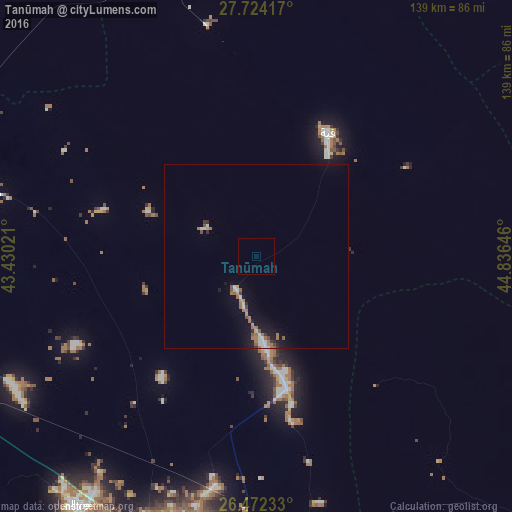
Analysis of Tanūmah night lights 2016
Square area 10x10 km:
 0%
0%90-99
0%80-89
0%70-79
0%60-69
0%50-59
0%40-49
0%30-39
0%20-29
0%10-19
0%0-9
100%Square area 50x50 km:
0.17%90-99
0.33%80-89
0.13%70-79
0.15%60-69
0.72%50-59
0.31%40-49
0.15%30-39
0.19%20-29
0.19%10-19
1.64%0-9
96.02%Clear (daylight) street map image can be seen on geolist.org.
Map coordinates:
27° 43' 27" North, 43° 25' 48.8" East
27° 6' 0" North, 44° 7' 60" East
26° 28' 20.4" North, 44° 50' 11.3" East
Some cities around Tanūmah sort by population:
• Buraydah
87.5 km =54.4 mi,  190°
190°
• Ar Rass
150.8 km =93.7 mi,  204°
204°
• Al Mithnab
138.1 km =85.8 mi,  176°
176°
• Az Zulfī
111.9 km =69.5 mi,  142°
142°
• Al Bukayrīyah
116.8 km =72.6 mi, 203°
• Adh Dhibiyah
153.8 km =95.6 mi,  219°
219°
• Al Arţāwīyah
137.6 km =85.5 mi,  118°
118°
• Al Fuwayliq
114 km =70.8 mi,  230°
230°
101581 (p: 13,594)
Sources (retrieved 2019-11-25):
» Earth at Night: Flat Maps 2012, 2016