Tomarovka night lights from space
Night Light of Tomarovka (Belgorod Oblast) from space (Russia) Src. Average luminocity for 10x10km area is 2.5214% and for 50x50km: 4.4318%.
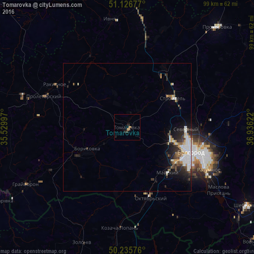
Analysis of Tomarovka night lights 2016
Square area 10x10 km:
 0%
0%90-99
0%80-89
0%70-79
0.53%60-69
1.6%50-59
0%40-49
0%30-39
0.94%20-29
1.74%10-19
0.53%0-9
94.65%Square area 50x50 km:
1.08%90-99
0.93%80-89
0.23%70-79
0.43%60-69
0.48%50-59
0.41%40-49
0.48%30-39
0.65%20-29
1.39%10-19
2.1%0-9
91.81%Clear (daylight) street map image can be seen on geolist.org.
Map coordinates:
51° 7' 36.4" North, 35° 31' 47.9" East
50° 41' 0.2" North, 36° 13' 59.1" East
50° 14' 8.7" North, 36° 56' 10.4" East
Some cities around Tomarovka sort by population:
• Belgorod
25.8 km =16 mi,  108°
108°
• Stroitel’
20.9 km =13 mi,  57°
57°
• Borisovka
17.8 km =11.1 mi,  239°
239°
• Rakitnoye
31.9 km =19.8 mi,  302°
302°
• Proletarskiy
34.5 km =21.4 mi,  290°
290°
• Severnyy
22.6 km =14 mi,  91°
91°
• Mayskiy
24.2 km =15 mi,  138°
138°
• Golovchino
35 km =21.7 mi, 241°
482275 (p: 7,916)
Sources (retrieved 2019-11-25):
» Earth at Night: Flat Maps 2012, 2016