Mayskiy night lights from space
Night Light of Mayskiy (Belgorod Oblast) from space (Russia) Src. Average luminocity for 10x10km area is 12.9412% and for 50x50km: 8.4569%.
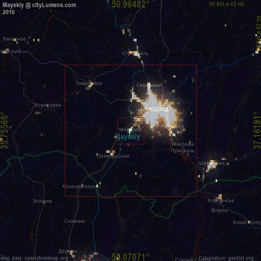
Analysis of Mayskiy night lights 2016
Square area 10x10 km:
 0.98%
0.98%90-99
1.4%80-89
0.56%70-79
1.68%60-69
1.54%50-59
3.22%40-49
2.94%30-39
2.38%20-29
3.36%10-19
12.61%0-9
69.33%Square area 50x50 km:
2.21%90-99
1.75%80-89
0.56%70-79
0.75%60-69
0.87%50-59
0.68%40-49
1.06%30-39
1.46%20-29
2.6%10-19
3.94%0-9
84.12%Clear (daylight) street map image can be seen on geolist.org.
Map coordinates:
50° 57' 53.4" North, 35° 45' 20.4" East
50° 31' 11.6" North, 36° 27' 31.6" East
50° 4' 14.6" North, 37° 9' 42.9" East
Some cities around Mayskiy sort by population:
• Belgorod
13.2 km =8.2 mi,  40°
40°
• Stroitel’
29.6 km =18.4 mi,  3°
3°
• Razumnoye
16 km =9.9 mi,  84°
84°
• Borisovka
32.6 km =20.3 mi,  286°
286°
• Tomarovka
24.2 km =15 mi,  318°
318°
• Severnyy
18.7 km =11.6 mi,  20°
20°
• Maslova Pristan’
19.8 km =12.3 mi,  110°
110°
• Novaya Tavolzhanka
32.3 km =20.1 mi,  125°
125°
528239 (p: 7,537)
Sources (retrieved 2019-11-25):
» Earth at Night: Flat Maps 2012, 2016