Severnyy night lights from space
Night Light of Severnyy (Belgorod Oblast) from space (Russia) Src. Average luminocity for 10x10km area is 22.3904% and for 50x50km: 8.755%.
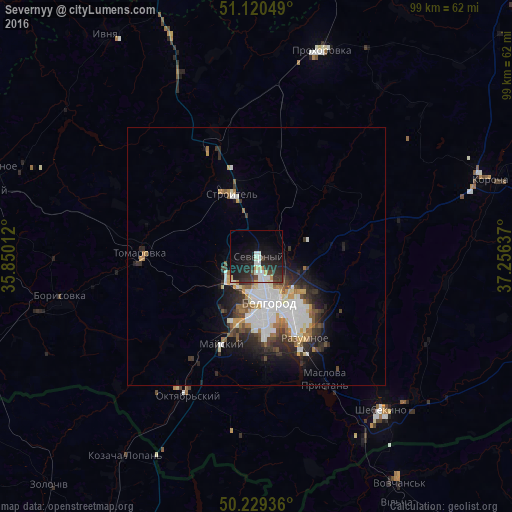
Analysis of Severnyy night lights 2016
Square area 10x10 km:
 3.88%
3.88%90-99
4.68%80-89
1.47%70-79
2.01%60-69
0.53%50-59
0%40-49
3.48%30-39
3.88%20-29
14.04%10-19
22.19%0-9
43.85%Square area 50x50 km:
2.25%90-99
1.82%80-89
0.54%70-79
0.81%60-69
0.95%50-59
0.71%40-49
1.01%30-39
1.52%20-29
2.64%10-19
3.97%0-9
83.78%Clear (daylight) street map image can be seen on geolist.org.
Map coordinates:
51° 7' 13.8" North, 35° 51' 0.4" East
50° 40' 37.3" North, 36° 33' 11.7" East
50° 13' 45.7" North, 37° 15' 22.9" East
Some cities around Severnyy sort by population:
• Belgorod
7.6 km =4.7 mi,  165°
165°
• Shebekino
39.1 km =24.3 mi,  139°
139°
• Stroitel’
13 km =8.1 mi,  337°
337°
• Razumnoye
18.4 km =11.4 mi,  149°
149°
• Borisovka
38.8 km =24.1 mi,  257°
257°
• Tomarovka
22.6 km =14 mi,  271°
271°
• Mayskiy
18.7 km =11.6 mi,  200°
200°
• Maslova Pristan’
27.1 km =16.8 mi, 154°
496358 (p: 7,752)
Sources (retrieved 2019-11-25):
» Earth at Night: Flat Maps 2012, 2016