Borisovka night lights from space
Night Light of Borisovka (Belgorod Oblast) from space (Russia) Src. Average luminocity for 10x10km area is 0.7179% and for 50x50km: 0.4976%.
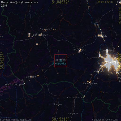
Analysis of Borisovka night lights 2016
Square area 10x10 km:
 0%
0%90-99
0%80-89
0%70-79
0%60-69
0%50-59
0%40-49
0.4%30-39
0.67%20-29
0.8%10-19
0.53%0-9
97.59%Square area 50x50 km:
0.01%90-99
0.02%80-89
0.06%70-79
0.04%60-69
0.13%50-59
0.18%40-49
0.08%30-39
0.15%20-29
0.23%10-19
0.19%0-9
98.93%Clear (daylight) street map image can be seen on geolist.org.
Map coordinates:
51° 2' 44.6" North, 35° 18' 44.5" East
50° 36' 5.6" North, 36° 0' 55.8" East
50° 9' 11.3" North, 36° 43' 7" East
Some cities around Borisovka sort by population:
• Zolochiv, UA
35.8 km =22.2 mi,  183°
183°
• Rakitnoye
28.8 km =17.9 mi,  336°
336°
• Proletarskiy
27.1 km =16.8 mi,  321°
321°
• Krasnaya Yaruga
33.5 km =20.8 mi,  311°
311°
• Tomarovka
17.8 km =11.1 mi,  59°
59°
• Mayskiy
32.6 km =20.3 mi,  106°
106°
• Grayvoron
27.6 km =17.1 mi,  239°
239°
• Golovchino
17.2 km =10.7 mi, 244°
572500 (p: 14,148)
Sources (retrieved 2019-11-25):
» Earth at Night: Flat Maps 2012, 2016