Razumnoye night lights from space
Night Light of Razumnoye (Belgorod Oblast) from space (Russia) Src. Average luminocity for 10x10km area is 44.521% and for 50x50km: 8.9295%.
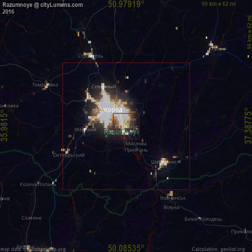
Analysis of Razumnoye night lights 2016
Square area 10x10 km:
 10.5%
10.5%90-99
8.96%80-89
3.5%70-79
4.06%60-69
7.28%50-59
3.92%40-49
4.34%30-39
9.38%20-29
16.53%10-19
18.77%0-9
12.75%Square area 50x50 km:
2.28%90-99
1.85%80-89
0.59%70-79
0.78%60-69
0.87%50-59
0.72%40-49
1.08%30-39
1.58%20-29
2.62%10-19
4.11%0-9
83.51%Clear (daylight) street map image can be seen on geolist.org.
Map coordinates:
50° 58' 45.1" North, 35° 58' 53.4" East
50° 32' 3.8" North, 36° 41' 4.6" East
50° 5' 7.3" North, 37° 23' 15.9" East
Some cities around Razumnoye sort by population:
• Belgorod
11.2 km =7 mi,  319°
319°
• Shebekino
21.3 km =13.2 mi,  130°
130°
• Vovchans’k, UA
32.6 km =20.3 mi,  146°
146°
• Stroitel’
31.3 km =19.4 mi,  333°
333°
• Severnyy
18.4 km =11.4 mi, 329°
• Mayskiy
16 km =9.9 mi,  264°
264°
• Maslova Pristan’
8.9 km =5.5 mi,  163°
163°
• Novaya Tavolzhanka
22.8 km =14.2 mi, 153°
502400 (p: 15,529)
Sources (retrieved 2019-11-25):
» Earth at Night: Flat Maps 2012, 2016