Maslova Pristan’ night lights from space
Night Light of Maslova Pristan’ (Belgorod Oblast) from space (Russia) Src. Average luminocity for 10x10km area is 2.8109% and for 50x50km: 8.9038%.
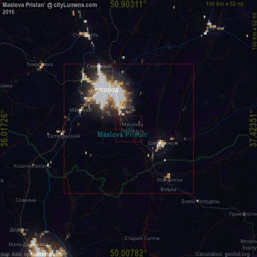
Analysis of Maslova Pristan’ night lights 2016
Square area 10x10 km:
 0%
0%90-99
0%80-89
0%70-79
0%60-69
0%50-59
0%40-49
0.56%30-39
0.28%20-29
1.54%10-19
7.7%0-9
89.92%Square area 50x50 km:
2.31%90-99
1.84%80-89
0.58%70-79
0.84%60-69
0.89%50-59
0.71%40-49
1.11%30-39
1.53%20-29
2.73%10-19
3.92%0-9
83.54%Clear (daylight) street map image can be seen on geolist.org.
Map coordinates:
50° 54' 11.2" North, 36° 1' 2.1" East
50° 27' 27.3" North, 36° 43' 13.4" East
50° 0' 28.2" North, 37° 25' 24.6" East
Some cities around Maslova Pristan’ sort by population:
• Belgorod
19.7 km =12.2 mi,  329°
329°
• Shebekino
14.7 km =9.1 mi,  111°
111°
• Vovchans’k, UA
24.3 km =15.1 mi,  139°
139°
• Stroitel’
40.1 km =24.9 mi,  335°
335°
• Razumnoye
8.9 km =5.5 mi, 343°
• Severnyy
27.1 km =16.8 mi, 334°
• Mayskiy
19.8 km =12.3 mi,  290°
290°
• Novaya Tavolzhanka
14.1 km =8.8 mi,  146°
146°
528741 (p: 5,669)
Sources (retrieved 2019-11-25):
» Earth at Night: Flat Maps 2012, 2016