Rio Maior night lights from space
Night Light of Rio Maior (Santarém) from space (Portugal) Src. Average luminocity for 10x10km area is 24.9031% and for 50x50km: 22.7653%.
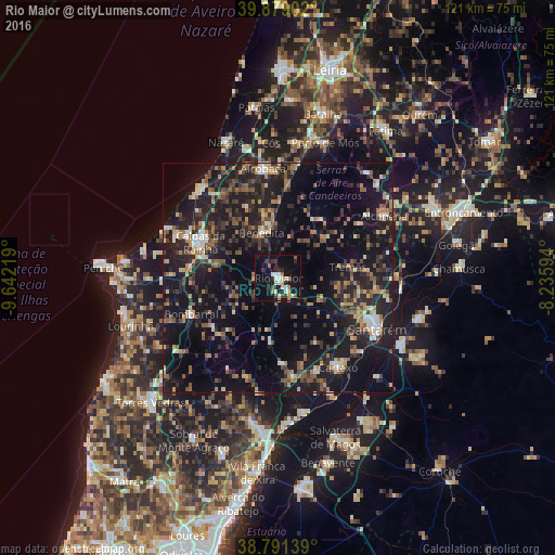
Analysis of Rio Maior night lights 2016
Square area 10x10 km:
 2.89%
2.89%90-99
3.23%80-89
5.27%70-79
1.53%60-69
2.55%50-59
2.55%40-49
1.7%30-39
3.4%20-29
5.27%10-19
38.27%0-9
33.33%Square area 50x50 km:
1.17%90-99
2.38%80-89
2.11%70-79
2.4%60-69
3.4%50-59
3.91%40-49
3.58%30-39
4.41%20-29
9.88%10-19
28.3%0-9
38.47%Clear (daylight) street map image can be seen on geolist.org.
Map coordinates:
39° 52' 44.5" North, 9° 38' 31.9" West
39° 20' 14.4" North, 8° 56' 20.6" West
38° 47' 29" North, 8° 14' 9.4" West
Some cities around Rio Maior sort by population:
• Monsanto
23.9 km =14.9 mi,  54°
54°
• Caldas da Rainha
18.6 km =11.6 mi,  293°
293°
• Alcobaça
24.1 km =15 mi,  352°
352°
• Óbidos
18.9 km =11.7 mi,  277°
277°
• Cartaxo
23.6 km =14.7 mi,  146°
146°
• Benedita
10.1 km =6.3 mi,  344°
344°
• Bombarral
20.4 km =12.7 mi,  247°
247°
• Alcanede
13.3 km =8.3 mi, 49°
2263823 (p: 12,064)
Sources (retrieved 2019-11-25):
» Earth at Night: Flat Maps 2012, 2016