Alcobaça night lights from space
Night Light of Alcobaça (Leiria) from space (Portugal) Src. Average luminocity for 10x10km area is 39.7792% and for 50x50km: 23.4044%.
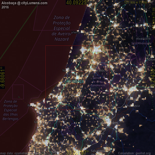
Analysis of Alcobaça night lights 2016
Square area 10x10 km:
 2.92%
2.92%90-99
5.19%80-89
5.68%70-79
3.25%60-69
6.17%50-59
7.63%40-49
5.19%30-39
10.06%20-29
29.38%10-19
24.51%0-9
0%Square area 50x50 km:
1.78%90-99
2.97%80-89
2.02%70-79
2.41%60-69
3.58%50-59
4.74%40-49
3.85%30-39
5.24%20-29
9.72%10-19
23.24%0-9
40.44%Clear (daylight) street map image can be seen on geolist.org.
Map coordinates:
40° 5' 32.1" North, 9° 40' 50.2" West
39° 33' 8" North, 8° 58' 39" West
39° 0' 28.7" North, 8° 16' 27.7" West
Some cities around Alcobaça sort by population:
• Maceira
16.7 km =10.4 mi,  25°
25°
• Nazaré
9.6 km =6 mi,  305°
305°
• Benedita
14.2 km =8.8 mi,  177°
177°
• Batalha
17.8 km =11.1 mi,  47°
47°
• Aljubarrota
4.5 km =2.8 mi,  68°
68°
• Porto de Mós
14.7 km =9.1 mi, 67°
• Pataias
13.2 km =8.2 mi,  353°
353°
• Alcanede
20.3 km =12.6 mi,  138°
138°
2272147 (p: 15,800)
Sources (retrieved 2019-11-25):
» Earth at Night: Flat Maps 2012, 2016