Cartaxo night lights from space
Night Light of Cartaxo (Santarém) from space (Portugal) Src. Average luminocity for 10x10km area is 29.0942% and for 50x50km: 21.5704%.
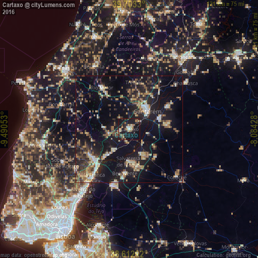
Analysis of Cartaxo night lights 2016
Square area 10x10 km:
 1.46%
1.46%90-99
3.9%80-89
3.57%70-79
3.25%60-69
3.9%50-59
4.55%40-49
4.55%30-39
4.38%20-29
9.25%10-19
48.54%0-9
12.66%Square area 50x50 km:
1.42%90-99
3.02%80-89
2.52%70-79
2.47%60-69
2.77%50-59
3.3%40-49
3.15%30-39
3.7%20-29
7.16%10-19
23.83%0-9
46.65%Clear (daylight) street map image can be seen on geolist.org.
Map coordinates:
39° 42' 11.9" North, 9° 29' 25.9" West
39° 9' 36.8" North, 8° 47' 14.7" West
38° 36' 46.5" North, 8° 5' 3.4" West
Some cities around Cartaxo sort by population:
• Santarém
12.1 km =7.5 mi,  47°
47°
• Almeirim
14.9 km =9.3 mi,  68°
68°
• Benavente
20.2 km =12.6 mi,  184°
184°
• Alpiarça
20.7 km =12.9 mi,  58°
58°
• Azambuja
12.2 km =7.6 mi,  214°
214°
• Fazendas de Almeirim
18.9 km =11.7 mi,  84°
84°
• Marinhais
14.5 km =9 mi,  149°
149°
• Salvaterra de Magos
14.7 km =9.1 mi, 182°
2270023 (p: 10,502)
Sources (retrieved 2019-11-25):
» Earth at Night: Flat Maps 2012, 2016