Benedita night lights from space
Night Light of Benedita (Leiria) from space (Portugal) Src. Average luminocity for 10x10km area is 28.9592% and for 50x50km: 22.5888%.
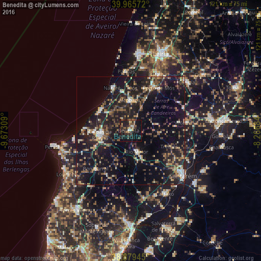
Analysis of Benedita night lights 2016
Square area 10x10 km:
 1.19%
1.19%90-99
2.89%80-89
2.04%70-79
3.91%60-69
3.23%50-59
3.74%40-49
7.99%30-39
7.48%20-29
15.14%10-19
41.5%0-9
10.88%Square area 50x50 km:
1.28%90-99
2.46%80-89
2.1%70-79
2.37%60-69
3.19%50-59
3.87%40-49
3.44%30-39
4.8%20-29
10.57%10-19
27.66%0-9
38.26%Clear (daylight) street map image can be seen on geolist.org.
Map coordinates:
39° 57' 56.6" North, 9° 40' 23.1" West
39° 25' 28.9" North, 8° 58' 11.9" West
38° 52' 46" North, 8° 16' 0.6" West
Some cities around Benedita sort by population:
• Monsanto
22.6 km =14 mi,  79°
79°
• Caldas da Rainha
14.7 km =9.1 mi,  260°
260°
• Alcobaça
14.2 km =8.8 mi,  357°
357°
• Rio Maior
10.1 km =6.3 mi,  164°
164°
• Óbidos
17.6 km =10.9 mi,  246°
246°
• Nazaré
21.5 km =13.4 mi,  336°
336°
• Aljubarrota
16.2 km =10.1 mi,  12°
12°
• Alcanede
12.8 km =8 mi,  94°
94°
2270935 (p: 8,556)
Sources (retrieved 2019-11-25):
» Earth at Night: Flat Maps 2012, 2016