Bombarral night lights from space
Night Light of Bombarral (Leiria) from space (Portugal) Src. Average luminocity for 10x10km area is 22.8571% and for 50x50km: 24.108%.
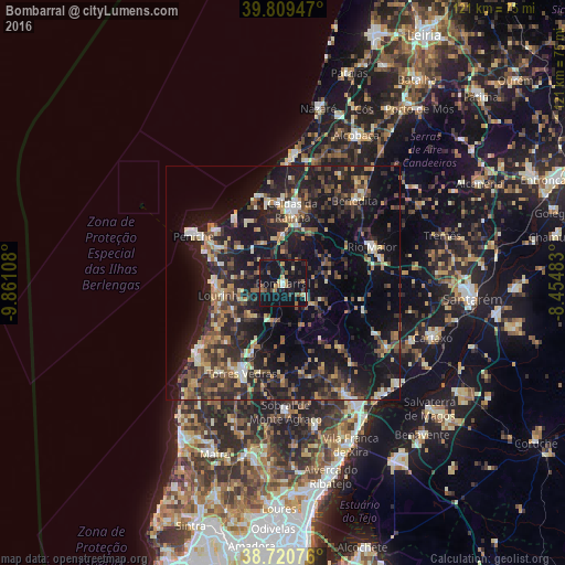
Analysis of Bombarral night lights 2016
Square area 10x10 km:
 1.02%
1.02%90-99
1.19%80-89
2.04%70-79
2.55%60-69
5.44%50-59
3.23%40-49
1.53%30-39
3.91%20-29
7.14%10-19
57.99%0-9
13.95%Square area 50x50 km:
1.46%90-99
2.62%80-89
2.6%70-79
2.6%60-69
3.95%50-59
4.03%40-49
3.59%30-39
5.82%20-29
10.46%10-19
26.42%0-9
36.45%Clear (daylight) street map image can be seen on geolist.org.
Map coordinates:
39° 48' 34.1" North, 9° 51' 39.9" West
39° 16' 2" North, 9° 9' 28.6" West
38° 43' 14.7" North, 8° 27' 17.4" West
Some cities around Bombarral sort by population:
• Caldas da Rainha
15.2 km =9.4 mi,  6°
6°
• Torres Vedras
21.4 km =13.3 mi,  203°
203°
• Rio Maior
20.4 km =12.7 mi,  67°
67°
• Óbidos
10.4 km =6.5 mi,  0°
0°
• Lourinhã
13.6 km =8.5 mi,  257°
257°
• Atouguia da Baleia
16.5 km =10.3 mi,  298°
298°
• A dos Cunhados
17.5 km =10.9 mi,  223°
223°
• Ventosa
16.8 km =10.4 mi,  157°
157°
2270770 (p: 5,852)
Sources (retrieved 2019-11-25):
» Earth at Night: Flat Maps 2012, 2016