Alcanede night lights from space
Night Light of Alcanede (Santarém) from space (Portugal) Src. Average luminocity for 10x10km area is 18.0697% and for 50x50km: 23.2183%.
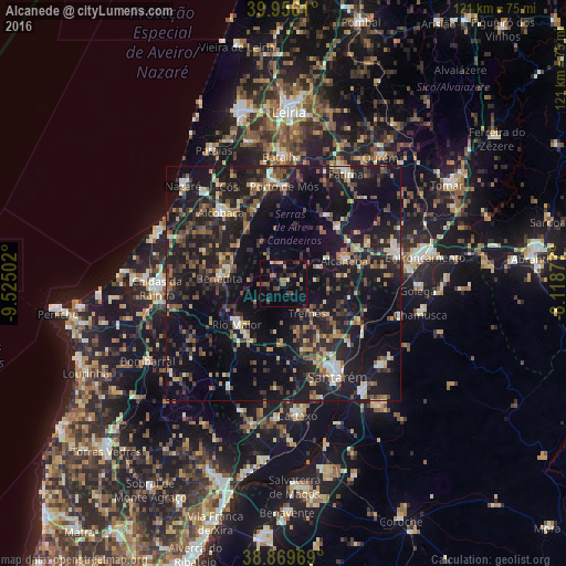
Analysis of Alcanede night lights 2016
Square area 10x10 km:
 0%
0%90-99
1.53%80-89
1.87%70-79
0.34%60-69
4.76%50-59
2.55%40-49
4.25%30-39
5.44%20-29
5.61%10-19
6.97%0-9
66.67%Square area 50x50 km:
1.3%90-99
2.54%80-89
1.95%70-79
2.24%60-69
3.28%50-59
3.89%40-49
4.01%30-39
4.66%20-29
10.08%10-19
29.82%0-9
36.23%Clear (daylight) street map image can be seen on geolist.org.
Map coordinates:
39° 57' 22" North, 9° 31' 30.1" West
39° 24' 54" North, 8° 49' 18.8" West
38° 52' 10.9" North, 8° 7' 7.6" West
Some cities around Alcanede sort by population:
• Monsanto
10.8 km =6.7 mi,  61°
61°
• Santarém
23.5 km =14.6 mi,  149°
149°
• Alcobaça
20.3 km =12.6 mi,  318°
318°
• Torres Novas
24.8 km =15.4 mi,  74°
74°
• Rio Maior
13.3 km =8.3 mi,  229°
229°
• Benedita
12.8 km =8 mi,  274°
274°
• Aljubarrota
19.3 km =12 mi,  331°
331°
• Porto de Mós
20.8 km =12.9 mi,  0°
0°
2272190 (p: 5,020)
Sources (retrieved 2019-11-25):
» Earth at Night: Flat Maps 2012, 2016