Olival night lights from space
Night Light of Olival (Porto) from space (Portugal) Src. Average luminocity for 10x10km area is 87.2313% and for 50x50km: 47.2299%.
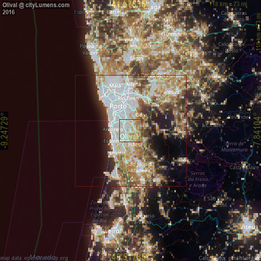
Analysis of Olival night lights 2016
Square area 10x10 km:
100  24.66%
90-99 27.21%
80-89 18.71%
70-79 15.99%
60-69 10.54%
50-59 2.89%
40-49 0%
30-39 0%
20-29 0%
10-19 0%
0-9 0%
24.66%90-99
27.21%80-89
18.71%70-79
15.99%60-69
10.54%50-59
2.89%40-49
0%30-39
0%20-29
0%10-19
0%0-9
0%Square area 50x50 km:
100 13.67%
90-99 9.81%
80-89 5.24%
70-79 6.91%
60-69 7.66%
50-59 5.15%
40-49 4.54%
30-39 4.8%
20-29 6.27%
10-19 7.47%
0-9 28.48%
13.67%90-99
9.81%80-89
5.24%70-79
6.91%60-69
7.66%50-59
5.15%40-49
4.54%30-39
4.8%20-29
6.27%10-19
7.47%0-9
28.48%Clear (daylight) street map image can be seen on geolist.org.
Map coordinates:
41° 34' 42.1" North, 9° 14' 50.2" West
41° 3' 0.9" North, 8° 32' 39" West
40° 31' 4.3" North, 7° 50' 27.7" West
Some cities around Olival sort by population:
• Canelas
6 km =3.7 mi,  308°
308°
• Grijó
3.9 km =2.4 mi,  231°
231°
• Argoncilhe
2.8 km =1.7 mi,  170°
170°
• Fiães
6.4 km =4 mi, 165°
• Serzedo
6 km =3.7 mi,  270°
270°
• Sandim
3.5 km =2.2 mi,  118°
118°
• Foz do Sousa
6.3 km =3.9 mi,  34°
34°
• Perozinho
3.8 km =2.4 mi,  295°
295°
2737064 (p: 5,715)
Sources (retrieved 2019-11-25):
» Earth at Night: Flat Maps 2012, 2016