Sandim night lights from space
Night Light of Sandim (Porto) from space (Portugal) Src. Average luminocity for 10x10km area is 75.0204% and for 50x50km: 47.2683%.
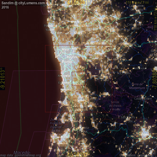
Analysis of Sandim night lights 2016
Square area 10x10 km:
100  11.56%
90-99 15.99%
80-89 17.18%
70-79 21.26%
60-69 13.61%
50-59 6.63%
40-49 7.31%
30-39 5.78%
20-29 0.68%
10-19 0%
0-9 0%
11.56%90-99
15.99%80-89
17.18%70-79
21.26%60-69
13.61%50-59
6.63%40-49
7.31%30-39
5.78%20-29
0.68%10-19
0%0-9
0%Square area 50x50 km:
100 13.2%
90-99 9.3%
80-89 5.3%
70-79 6.63%
60-69 7.59%
50-59 5.7%
40-49 4.81%
30-39 5.37%
20-29 7.84%
10-19 8.27%
0-9 25.99%
13.2%90-99
9.3%80-89
5.3%70-79
6.63%60-69
7.59%50-59
5.7%40-49
4.81%30-39
5.37%20-29
7.84%10-19
8.27%0-9
25.99%Clear (daylight) street map image can be seen on geolist.org.
Map coordinates:
41° 33' 47.9" North, 9° 12' 36.5" West
41° 2' 6.3" North, 8° 30' 25.2" West
40° 30' 9.3" North, 7° 48' 14" West
Some cities around Sandim sort by population:
• Grijó
6.2 km =3.9 mi,  263°
263°
• Lourosa
6.8 km =4.2 mi,  213°
213°
• Argoncilhe
2.9 km =1.8 mi,  248°
248°
• Fiães
4.8 km =3 mi,  198°
198°
• Foz do Sousa
6.9 km =4.3 mi,  3°
3°
• Perozinho
7.4 km =4.6 mi,  296°
296°
• Lobão
5.7 km =3.5 mi,  161°
161°
• Olival
3.5 km =2.2 mi, 298°
2734803 (p: 6,449)
Sources (retrieved 2019-11-25):
» Earth at Night: Flat Maps 2012, 2016