Fiães night lights from space
Night Light of Fiães (Aveiro) from space (Portugal) Src. Average luminocity for 10x10km area is 79.2806% and for 50x50km: 42.7637%.
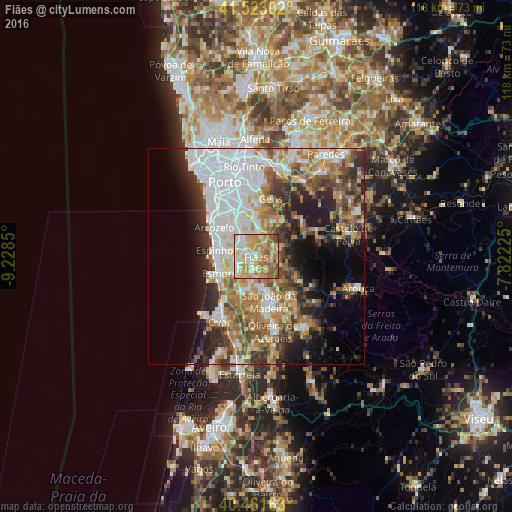
Analysis of Fiães night lights 2016
Square area 10x10 km:
 11.39%
90-99
17.35%80-89
20.92%70-79
24.66%60-69
15.99%50-59
7.65%40-49
1.7%30-39
0.34%20-29
0%10-19
0%0-9
0%Square area 50x50 km:
11.25%90-99
8.17%80-89
4.71%70-79
5.62%60-69
7.22%50-59
5.56%40-49
4.69%30-39
5.61%20-29
7.64%10-19
9.02%0-9
30.5%Clear (daylight) street map image can be seen on geolist.org.
Map coordinates:
41° 31' 22.9" North, 9° 13' 42.6" West
40° 59' 40.1" North, 8° 31' 31.3" West
40° 27' 41.9" North, 7° 49' 20.1" West
Some cities around Fiães sort by population:
• Grijó
5.9 km =3.7 mi,  309°
309°
• Lourosa
2.5 km =1.6 mi,  242°
242°
• São João de Ver
4.9 km =3 mi,  206°
206°
• Argoncilhe
3.6 km =2.2 mi,  341°
341°
• Sandim
4.8 km =3 mi,  18°
18°
• Lobão
3.4 km =2.1 mi,  104°
104°
• Lamas
3.8 km =2.4 mi,  255°
255°
• Nogueira da Regedoura
5.7 km =3.5 mi,  282°
282°
2739613 (p: 8,708)
Sources (retrieved 2019-11-25):
» Earth at Night: Flat Maps 2012, 2016