‘Azzūn night lights from space
Night Light of ‘Azzūn (West Bank) from space (Palestinian Territory) Src. Average luminocity for 10x10km area is 62.4143% and for 50x50km: 67.0632%.
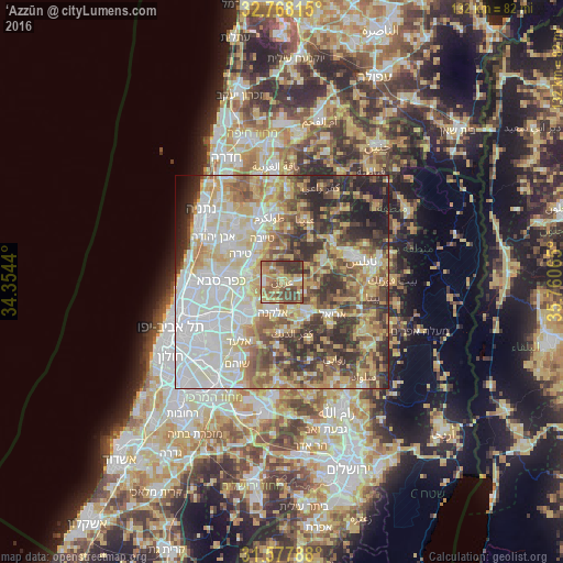
Analysis of ‘Azzūn night lights 2016
Square area 10x10 km:
 2.97%
2.97%90-99
5.07%80-89
14.86%70-79
15.03%60-69
14.16%50-59
22.03%40-49
11.19%30-39
13.99%20-29
0.7%10-19
0%0-9
0%Square area 50x50 km:
15.25%90-99
14.81%80-89
12.77%70-79
9.9%60-69
6.84%50-59
8.57%40-49
10.3%30-39
8.43%20-29
9.1%10-19
3.41%0-9
0.61%Clear (daylight) street map image can be seen on geolist.org.
Map coordinates:
32° 46' 5.3" North, 34° 21' 15.8" East
32° 10' 29.9" North, 35° 3' 27.1" East
31° 34' 40.4" North, 35° 45' 38.3" East
Some cities around ‘Azzūn sort by population:
• Qalqīlyah
8.3 km =5.2 mi,  281°
281°
• Eṭ Ṭaiyiba, IL
11.1 km =6.9 mi,  335°
335°
• Kafr Qāsim, IL
10.2 km =6.3 mi,  228°
228°
• Bidyā
7 km =4.3 mi,  162°
162°
• Jaljūlya, IL
10 km =6.2 mi,  257°
257°
• Oranit
7.9 km =4.9 mi, 232°
• Ḩablah
7.6 km =4.7 mi, 261°
• Bayt Līd
11.8 km =7.3 mi,  36°
36°
284480 (p: 7,727)
Sources (retrieved 2019-11-25):
» Earth at Night: Flat Maps 2012, 2016