Jaljūlya night lights from space
Night Light of Jaljūlya (Central District) from space (Israel) Src. Average luminocity for 10x10km area is 93.2727% and for 50x50km: 63.6768%.
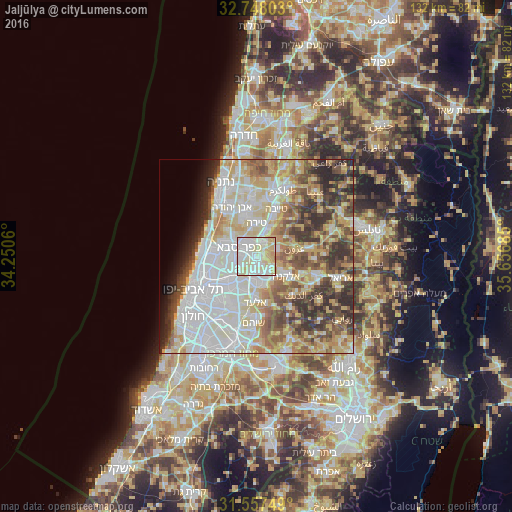
Analysis of Jaljūlya night lights 2016
Square area 10x10 km:
 29.55%
90-99
39.16%80-89
25.35%70-79
5.42%60-69
0.52%50-59
0%40-49
0%30-39
0%20-29
0%10-19
0%0-9
0%Square area 50x50 km:
17.35%90-99
15.46%80-89
11.55%70-79
8.09%60-69
5.55%50-59
7.02%40-49
8%30-39
6.7%20-29
7%10-19
3.01%0-9
10.26%Clear (daylight) street map image can be seen on geolist.org.
Map coordinates:
32° 44' 52.9" North, 34° 15' 2.2" East
32° 9' 16.9" North, 34° 57' 13.4" East
31° 33' 27" North, 35° 39' 24.7" East
Some cities around Jaljūlya sort by population:
• Kfar Saba
4.9 km =3 mi,  297°
297°
• Ra'anana
8.2 km =5.1 mi,  293°
293°
• Qalqīlyah, PS
4.2 km =2.6 mi,  22°
22°
• Hod HaSharon
5.7 km =3.5 mi,  275°
275°
• Rosh Ha‘Ayin
6.6 km =4.1 mi,  177°
177°
• Kafr Qāsim
5 km =3.1 mi,  154°
154°
• Oranit, PS
4.3 km =2.7 mi,  126°
126°
• Ḩablah, PS
2.5 km =1.6 mi,  62°
62°
294634 (p: 7,505)
Sources (retrieved 2019-11-25):
» Earth at Night: Flat Maps 2012, 2016