Bayt Līd night lights from space
Night Light of Bayt Līd (West Bank) from space (Palestinian Territory) Src. Average luminocity for 10x10km area is 47.6832% and for 50x50km: 61.8116%.
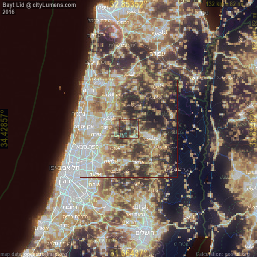
Analysis of Bayt Līd night lights 2016
Square area 10x10 km:
 1.47%
1.47%90-99
2.56%80-89
10.44%70-79
9.52%60-69
5.49%50-59
5.68%40-49
13.55%30-39
24.36%20-29
26.92%10-19
0%0-9
0%Square area 50x50 km:
9.79%90-99
12.35%80-89
13.24%70-79
10.92%60-69
7.62%50-59
8.36%40-49
10.19%30-39
9.09%20-29
10.81%10-19
6.48%0-9
1.15%Clear (daylight) street map image can be seen on geolist.org.
Map coordinates:
32° 51' 12.7" North, 34° 25' 42.9" East
32° 15' 39.2" North, 35° 7' 54.1" East
31° 39' 51.7" North, 35° 50' 5.4" East
Some cities around Bayt Līd sort by population:
• Ţūlkarm
11.1 km =6.9 mi,  299°
299°
• Eṭ Ṭaiyiba, IL
11.6 km =7.2 mi,  272°
272°
• Dayr al Ghuşūn
11.4 km =7.1 mi,  333°
333°
• Jaba‘
11 km =6.8 mi,  50°
50°
• Dhannābah
10.3 km =6.4 mi, 304°
• ‘Anabtā
5.4 km =3.4 mi,  345°
345°
• Bal‘ā
8.3 km =5.2 mi, 346°
• Sīlat az̧ Z̧ahr
8.2 km =5.1 mi,  37°
37°
284313 (p: 5,740)
Sources (retrieved 2019-11-25):
» Earth at Night: Flat Maps 2012, 2016