Rawa Mazowiecka night lights from space
Night Light of Rawa Mazowiecka (Łódź Voivodeship) from space (Poland) Src. Average luminocity for 10x10km area is 12.5028% and for 50x50km: 3.1851%.
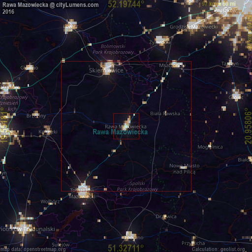
Analysis of Rawa Mazowiecka night lights 2016
Square area 10x10 km:
 1.26%
1.26%90-99
2.24%80-89
1.96%70-79
2.52%60-69
0.98%50-59
1.12%40-49
1.12%30-39
1.12%20-29
0.84%10-19
2.38%0-9
84.45%Square area 50x50 km:
0.55%90-99
0.71%80-89
0.25%70-79
0.35%60-69
0.49%50-59
0.24%40-49
0.26%30-39
0.25%20-29
0.32%10-19
1.9%0-9
94.68%Clear (daylight) street map image can be seen on geolist.org.
Map coordinates:
52° 11' 50.8" North, 19° 33' 6.5" East
51° 45' 51.7" North, 20° 15' 17.7" East
51° 19' 37.6" North, 20° 57' 29" East
Some cities around Rawa Mazowiecka sort by population:
• Tomaszów Mazowiecki
31 km =19.3 mi,  213°
213°
• Skierniewice
22.2 km =13.8 mi,  342°
342°
• Żyrardów
34.2 km =21.3 mi,  22°
22°
• Opoczno
43.2 km =26.8 mi,  177°
177°
• Głowno
43.2 km =26.8 mi,  301°
301°
• Koluszki
30.1 km =18.7 mi,  264°
264°
• Brzeziny
34.9 km =21.7 mi,  276°
276°
• Mszczonów
29.6 km =18.4 mi,  38°
38°
760584 (p: 17,770)
Sources (retrieved 2019-11-25):
» Earth at Night: Flat Maps 2012, 2016