Mszczonów night lights from space
Night Light of Mszczonów (Mazovia) from space (Poland) Src. Average luminocity for 10x10km area is 13.3119% and for 50x50km: 11.3943%.
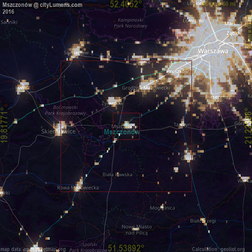
Analysis of Mszczonów night lights 2016
Square area 10x10 km:
 1.89%
1.89%90-99
3.54%80-89
0.88%70-79
1.01%60-69
1.52%50-59
0.76%40-49
0.51%30-39
1.77%20-29
0%10-19
2.9%0-9
85.23%Square area 50x50 km:
1.85%90-99
2.36%80-89
0.86%70-79
1.03%60-69
1.42%50-59
1.72%40-49
1.6%30-39
1.51%20-29
3.09%10-19
6.2%0-9
78.36%Clear (daylight) street map image can be seen on geolist.org.
Map coordinates:
52° 24' 18.7" North, 19° 49' 3.8" East
51° 58' 26.9" North, 20° 31' 15" East
51° 32' 20.1" North, 21° 13' 26.3" East
Some cities around Mszczonów sort by population:
• Skierniewice
24.9 km =15.5 mi,  265°
265°
• Żyrardów
9.8 km =6.1 mi,  328°
328°
• Grodzisk Mazowiecki
16.4 km =10.2 mi,  28°
28°
• Milanówek
19.1 km =11.9 mi, 32°
• Grójec
26.8 km =16.7 mi,  117°
117°
• Brwinów
23 km =14.3 mi,  35°
35°
• Błonie
25.8 km =16 mi,  14°
14°
• Nadarzyn
23.7 km =14.7 mi,  55°
55°
764269 (p: 6,267)
Sources (retrieved 2019-11-25):
» Earth at Night: Flat Maps 2012, 2016