Gostynin night lights from space
Night Light of Gostynin (Mazovia) from space (Poland) Src. Average luminocity for 10x10km area is 9.4028% and for 50x50km: 6.2825%.
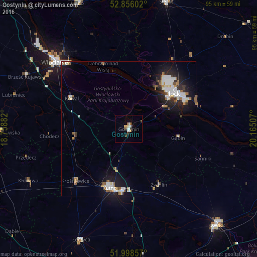
Analysis of Gostynin night lights 2016
Square area 10x10 km:
 1.89%
1.89%90-99
1.64%80-89
0.63%70-79
1.26%60-69
0.63%50-59
1.39%40-49
1.64%30-39
0.51%20-29
0%10-19
1.26%0-9
89.14%Square area 50x50 km:
1.33%90-99
1.4%80-89
0.51%70-79
0.45%60-69
0.55%50-59
0.79%40-49
0.45%30-39
0.6%20-29
1.51%10-19
4.74%0-9
87.66%Clear (daylight) street map image can be seen on geolist.org.
Map coordinates:
52° 51' 21.7" North, 18° 45' 31.8" East
52° 25' 45.8" North, 19° 27' 43" East
51° 59' 54.9" North, 20° 9' 54.3" East
Some cities around Gostynin sort by population:
• Płock
21.1 km =13.1 mi,  51°
51°
• Włocławek
36.1 km =22.4 mi,  312°
312°
• Kutno
23.1 km =14.4 mi,  196°
196°
• Łowicz
48.6 km =30.2 mi,  137°
137°
• Sierpc
49.5 km =30.8 mi,  16°
16°
• Łęczyca
44.8 km =27.8 mi, 203°
• Żychlin
23.4 km =14.5 mi,  151°
151°
• Kłodawa
42 km =26.1 mi,  242°
242°
3098619 (p: 18,976)
Sources (retrieved 2019-11-25):
» Earth at Night: Flat Maps 2012, 2016