Mochumí night lights from space
Night Light of Mochumí (Lambayeque) from space (Peru) Src. Average luminocity for 10x10km area is 5.513% and for 50x50km: 6.4428%.
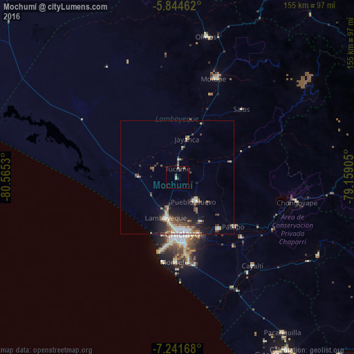
Analysis of Mochumí night lights 2016
Square area 10x10 km:
 0%
0%90-99
1.73%80-89
1.3%70-79
0%60-69
0.87%50-59
0%40-49
0%30-39
2.6%20-29
0.43%10-19
1.73%0-9
91.34%Square area 50x50 km:
0.69%90-99
1.21%80-89
0.74%70-79
0.55%60-69
0.68%50-59
0.81%40-49
1.4%30-39
1.24%20-29
1.69%10-19
3.67%0-9
87.31%Clear (daylight) street map image can be seen on geolist.org.
Map coordinates:
5° 50' 40.6" South, 80° 33' 55.1" West
6° 32' 37.1" South, 79° 51' 43.8" West
7° 14' 30" South, 79° 9' 32.6" West
Some cities around Mochumí sort by population:
• Lambayeque
18.2 km =11.3 mi,  195°
195°
• Picsi
21.9 km =13.6 mi,  152°
152°
• Ferreñafe
13.3 km =8.3 mi,  142°
142°
• Santa Rosa
24.1 km =15 mi,  170°
170°
• San José
22 km =13.7 mi, 169°
• Túcume
4.2 km =2.6 mi,  7°
7°
• Mórrope
16.5 km =10.3 mi,  273°
273°
• Jayanca
17.6 km =10.9 mi, 14°
3694720 (p: 7,460)
Sources (retrieved 2019-11-25):
» Earth at Night: Flat Maps 2012, 2016