Santa Rosa night lights from space
Night Light of Santa Rosa (Lambayeque) from space (Peru) Src. Average luminocity for 10x10km area is 71.1385% and for 50x50km: 12.7282%.
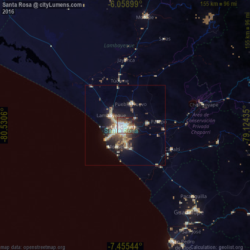
Analysis of Santa Rosa night lights 2016
Square area 10x10 km:
 19.26%
90-99
24.89%80-89
5.41%70-79
6.28%60-69
4.98%50-59
8.01%40-49
13.42%30-39
7.79%20-29
8.01%10-19
1.95%0-9
0%Square area 50x50 km:
1.3%90-99
2.75%80-89
1.71%70-79
1.25%60-69
1.27%50-59
1.55%40-49
2.62%30-39
2.39%20-29
3.38%10-19
6.88%0-9
74.89%Clear (daylight) street map image can be seen on geolist.org.
Map coordinates:
6° 3' 32.4" South, 80° 31' 50.2" West
6° 45' 27.8" South, 79° 49' 38.9" West
7° 27' 19.6" South, 79° 7' 27.7" West
Some cities around Santa Rosa sort by population:
• Chiclayo
2.1 km =1.3 mi,  224°
224°
• Lambayeque
10.7 km =6.6 mi,  305°
305°
• Picsi
7.8 km =4.8 mi,  55°
55°
• Ferreñafe
13.9 km =8.6 mi,  17°
17°
• Monsefú
13.7 km =8.5 mi,  199°
199°
• Pimentel
14.7 km =9.1 mi,  233°
233°
• Reque
12 km =7.5 mi,  174°
174°
• San José
2.2 km =1.4 mi,  359°
359°
3692116 (p: 10,625)
Sources (retrieved 2019-11-25):
» Earth at Night: Flat Maps 2012, 2016