San José night lights from space
Night Light of San José (Lambayeque) from space (Peru) Src. Average luminocity for 10x10km area is 57.342% and for 50x50km: 12.7394%.
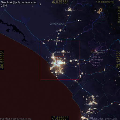
Analysis of San José night lights 2016
Square area 10x10 km:
 14.29%
90-99
18.83%80-89
3.46%70-79
5.19%60-69
2.81%50-59
5.63%40-49
9.96%30-39
8.23%20-29
14.72%10-19
16.67%0-9
0.22%Square area 50x50 km:
1.3%90-99
2.75%80-89
1.66%70-79
1.22%60-69
1.27%50-59
1.55%40-49
2.73%30-39
2.44%20-29
3.38%10-19
6.88%0-9
74.82%Clear (daylight) street map image can be seen on geolist.org.
Map coordinates:
6° 2' 21.8" South, 80° 31' 50.3" West
6° 44' 17.3" South, 79° 49' 39" West
7° 26' 9.2" South, 79° 7' 27.8" West
Some cities around San José sort by population:
• Chiclayo
4 km =2.5 mi,  201°
201°
• Lambayeque
9.6 km =6 mi,  295°
295°
• Picsi
6.8 km =4.2 mi,  70°
70°
• Ferreñafe
11.8 km =7.3 mi,  21°
21°
• Monsefú
15.8 km =9.8 mi, 196°
• Pimentel
16.1 km =10 mi,  227°
227°
• Santa Rosa
2.2 km =1.4 mi,  179°
179°
• Reque
14.2 km =8.8 mi, 175°
3692482 (p: 7,434)
Sources (retrieved 2019-11-25):
» Earth at Night: Flat Maps 2012, 2016