Tauranga night lights from space
Night Light of Tauranga (Bay of Plenty) from space (New Zealand) Src. Average luminocity for 10x10km area is 51.6922% and for 50x50km: 4.8307%.
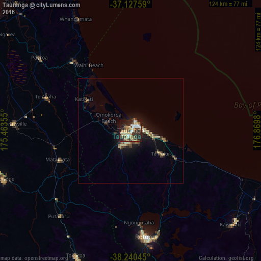
Analysis of Tauranga night lights 2016
Square area 10x10 km:
 7.48%
7.48%90-99
8.16%80-89
15.65%70-79
4.59%60-69
5.27%50-59
3.06%40-49
8.16%30-39
12.76%20-29
17.86%10-19
14.8%0-9
2.21%Square area 50x50 km:
0.34%90-99
0.53%80-89
1.22%70-79
0.45%60-69
0.49%50-59
0.38%40-49
0.87%30-39
1.15%20-29
1.29%10-19
3.77%0-9
89.52%Clear (daylight) street map image can be seen on geolist.org.
Map coordinates:
37° 7' 39.3" South, 175° 27' 48.8" East
37° 41' 10" South, 176° 10' 0" East
38° 14' 25.6" South, 176° 52' 11.3" East
Some cities around Tauranga sort by population:
• Hamilton
78.4 km =48.7 mi,  262°
262°
• Rotorua
50.8 km =31.6 mi,  172°
172°
• Whakatane
78 km =48.5 mi,  112°
112°
• Cambridge
67.3 km =41.8 mi,  251°
251°
• Tokoroa
66.3 km =41.2 mi,  203°
203°
• Thames
82.3 km =51.1 mi,  317°
317°
• Kawerau
65.6 km =40.8 mi,  134°
134°
• Matamata
38.1 km =23.7 mi, 248°
2208032 (p: 110,338)
Sources (retrieved 2019-11-25):
» NASA, Earths city lights 1995
» NASA city lights 2003
» Earth at Night: Flat Maps 2012, 2016