Askøy night lights from space
Night Light of Askøy (Hordaland) from space (Norway) Src. Average luminocity for 10x10km area is 50.2435% and for 50x50km: 15.2132%.
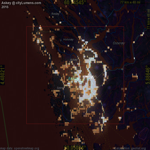
Analysis of Askøy night lights 2016
Square area 10x10 km:
100  9.85%
9.85%
90-99 10.61%
80-89 4.11%
70-79 5.09%
60-69 6.49%
50-59 8.77%
40-49 4%
30-39 10.61%
20-29 23.05%
10-19 17.42%
0-9 0%
9.85%90-99
10.61%80-89
4.11%70-79
5.09%60-69
6.49%50-59
8.77%40-49
4%30-39
10.61%20-29
23.05%10-19
17.42%0-9
0%Square area 50x50 km:
100 2.56%
90-99 2.65%
80-89 0.97%
70-79 1.25%
60-69 1.69%
50-59 3.74%
40-49 2.15%
30-39 1.99%
20-29 4.34%
10-19 10.06%
0-9 68.6%
2.56%90-99
2.65%80-89
0.97%70-79
1.25%60-69
1.69%50-59
3.74%40-49
2.15%30-39
1.99%20-29
4.34%10-19
10.06%0-9
68.6%Clear (daylight) street map image can be seen on geolist.org.
Map coordinates:
60° 44' 43.6" North, 4° 28' 48.8" East
60° 24' 0" North, 5° 10' 60" East
60° 3' 3" North, 5° 53' 11.3" East
Some cities around Askøy sort by population:
• Bergen
7.8 km =4.8 mi,  95°
95°
• Haugesund
109.8 km =68.2 mi,  177°
177°
• Ytrebygda
11.9 km =7.4 mi,  152°
152°
• Leirvik
71.2 km =44.2 mi,  165°
165°
• Førde
122.5 km =76.1 mi,  17°
17°
• Indre Arna
15.9 km =9.9 mi,  82°
82°
• Voss
72 km =44.7 mi,  69°
69°
• Odda
83.7 km =52 mi,  116°
116°
3336587 (p: 17,224)
Sources (retrieved 2019-11-25):
» Earth at Night: Flat Maps 2012, 2016