Leirvik night lights from space
Night Light of Leirvik (Hordaland) from space (Norway) Src. Average luminocity for 10x10km area is 23.0195% and for 50x50km: 3.0964%.
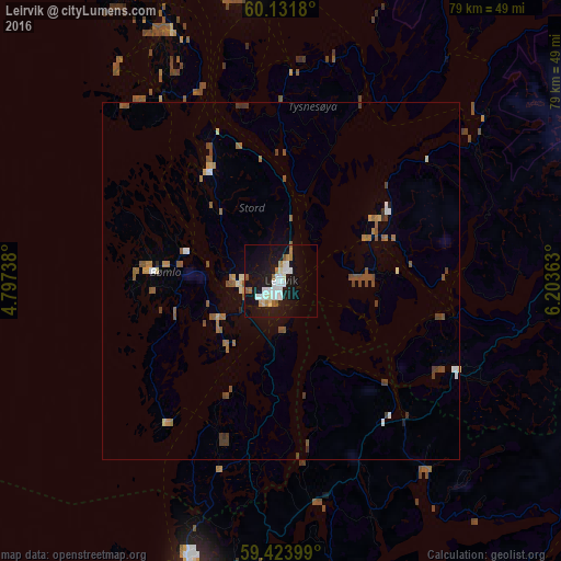
Analysis of Leirvik night lights 2016
Square area 10x10 km:
 5.19%
5.19%90-99
6.39%80-89
0.97%70-79
2.06%60-69
1.73%50-59
2.38%40-49
0.11%30-39
0%20-29
0.87%10-19
37.23%0-9
43.07%Square area 50x50 km:
0.35%90-99
0.41%80-89
0.22%70-79
0.25%60-69
0.51%50-59
0.83%40-49
0.52%30-39
0.38%20-29
0.1%10-19
1.67%0-9
94.77%Clear (daylight) street map image can be seen on geolist.org.
Map coordinates:
60° 7' 54.5" North, 4° 47' 50.6" East
59° 46' 47.2" North, 5° 30' 1.8" East
59° 25' 26.4" North, 6° 12' 13.1" East
Some cities around Leirvik sort by population:
• Bergen
68.9 km =42.8 mi,  351°
351°
• Haugesund
42.7 km =26.5 mi,  197°
197°
• Ytrebygda
59.6 km =37 mi, 348°
• Sæveland
59.5 km =37 mi, 196°
• Kopervik
56.2 km =34.9 mi,  191°
191°
• Indre Arna
70.9 km =44.1 mi,  358°
358°
• Odda
66.5 km =41.3 mi,  61°
61°
• Åkrehamn
60.4 km =37.5 mi, 197°
3147822 (p: 11,028)
Sources (retrieved 2019-11-25):
» Earth at Night: Flat Maps 2012, 2016