Kuala Kedah night lights from space
Night Light of Kuala Kedah (Kedah) from space (Malaysia) Src. Average luminocity for 10x10km area is 37.9132% and for 50x50km: 13.8823%.
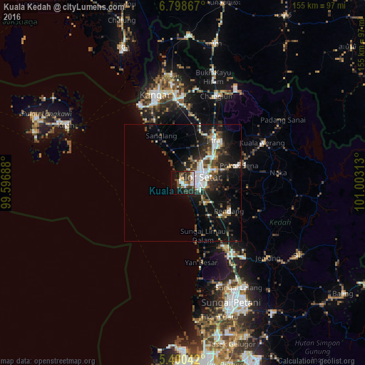
Analysis of Kuala Kedah night lights 2016
Square area 10x10 km:
 7.23%
7.23%90-99
7.64%80-89
1.24%70-79
3.1%60-69
3.93%50-59
7.23%40-49
6.2%30-39
11.57%20-29
11.36%10-19
19.21%0-9
21.28%Square area 50x50 km:
2.59%90-99
2.51%80-89
0.76%70-79
0.99%60-69
1.28%50-59
1.87%40-49
2.56%30-39
2.44%20-29
5.07%10-19
9.98%0-9
69.94%Clear (daylight) street map image can be seen on geolist.org.
Map coordinates:
6° 47' 55.2" North, 99° 35' 48.8" East
6° 6' 0" North, 100° 18' 0" East
5° 24' 1.5" North, 101° 0' 11.3" East
Some cities around Kuala Kedah sort by population:
• Sungai Petani
54.5 km =33.9 mi,  157°
157°
• Alor Setar
7 km =4.3 mi,  70°
70°
• Kangar
39.6 km =24.6 mi,  343°
343°
• Jitra
23 km =14.3 mi,  35°
35°
• Bedong
47.4 km =29.5 mi,  150°
150°
• Sadao, TH
61.4 km =38.2 mi,  12°
12°
• Kuah
56.4 km =35 mi,  296°
296°
• Gurun
36.9 km =22.9 mi, 148°
1736305 (p: 19,231)
Sources (retrieved 2019-11-25):
» Earth at Night: Flat Maps 2012, 2016