Tlachichuca night lights from space
Night Light of Tlachichuca (Puebla) from space (Mexico) Src. Average luminocity for 10x10km area is 4.3636% and for 50x50km: 5.1681%.
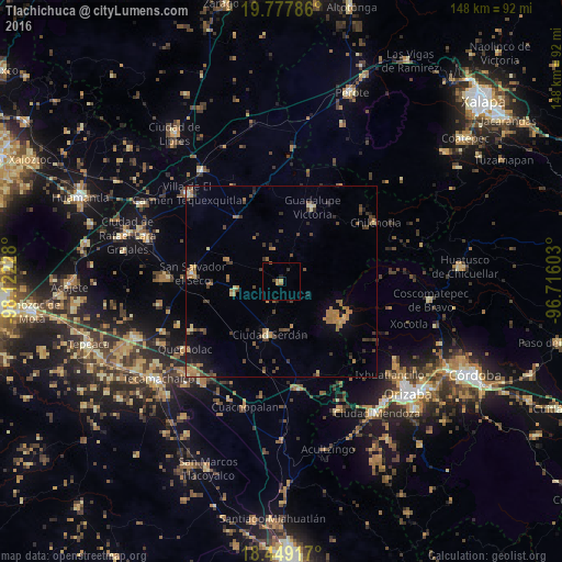
Analysis of Tlachichuca night lights 2016
Square area 10x10 km:
 0%
0%90-99
0%80-89
0%70-79
1.73%60-69
1.3%50-59
0.87%40-49
0%30-39
1.52%20-29
1.08%10-19
0%0-9
93.51%Square area 50x50 km:
0.02%90-99
0.11%80-89
0.68%70-79
0.87%60-69
1.43%50-59
0.85%40-49
1.42%30-39
1.06%20-29
0.58%10-19
1.89%0-9
91.11%Clear (daylight) street map image can be seen on geolist.org.
Map coordinates:
19° 46' 40.3" North, 98° 7' 20.2" West
19° 6' 53.5" North, 97° 25' 8.9" West
18° 26' 57" North, 96° 42' 57.7" West
Some cities around Tlachichuca sort by population:
• Ciudad Serdán
14.3 km =8.9 mi,  191°
191°
• San Salvador El Seco
23.5 km =14.6 mi,  275°
275°
• Quecholac
30.8 km =19.1 mi,  234°
234°
• Zacatepec
20.6 km =12.8 mi,  324°
324°
• Guadalupe Victoria
21.2 km =13.2 mi,  22°
22°
• Esperanza
28.9 km =18 mi,  171°
171°
• Soltepec
30.4 km =18.9 mi,  271°
271°
• Santa Maria Coatepec
18.2 km =11.3 mi, 268°
3515496 (p: 7,574)
Sources (retrieved 2019-11-25):
» Earth at Night: Flat Maps 2012, 2016