San Salvador El Seco night lights from space
Night Light of San Salvador El Seco (Puebla) from space (Mexico) Src. Average luminocity for 10x10km area is 12.5087% and for 50x50km: 12.1309%.
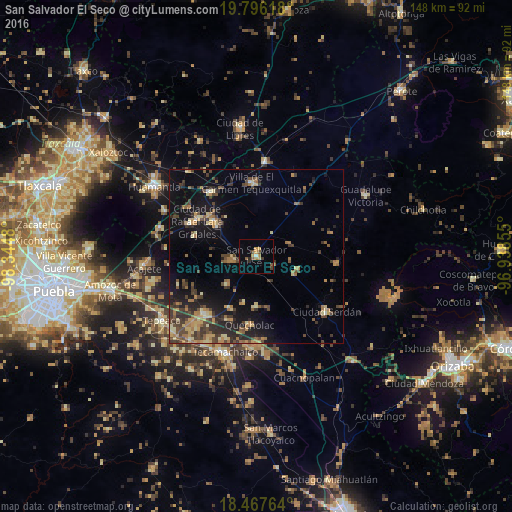
Analysis of San Salvador El Seco night lights 2016
Square area 10x10 km:
 0%
0%90-99
0.87%80-89
1.3%70-79
3.9%60-69
0.87%50-59
2.6%40-49
2.6%30-39
1.3%20-29
1.3%10-19
0.22%0-9
85.06%Square area 50x50 km:
0.08%90-99
0.49%80-89
2.12%70-79
1.77%60-69
2.39%50-59
1.56%40-49
3.43%30-39
2.9%20-29
3.07%10-19
8.27%0-9
73.91%Clear (daylight) street map image can be seen on geolist.org.
Map coordinates:
19° 47' 46.2" North, 98° 20' 41.3" West
19° 7' 59.7" North, 97° 38' 30" West
18° 28' 3.5" North, 96° 56' 18.8" West
Some cities around San Salvador El Seco sort by population:
• Villa de El Carmen Tequexquitla
21.3 km =13.2 mi,  356°
356°
• Quecholac
19.9 km =12.4 mi,  185°
185°
• Zacatepec
18.7 km =11.6 mi,  37°
37°
• Grajales
20 km =12.4 mi,  301°
301°
• Santa María Ixtiyucán
18.8 km =11.7 mi,  288°
288°
• Nopalucán
21.2 km =13.2 mi, 296°
• Soltepec
7.2 km =4.5 mi,  259°
259°
• Santa Maria Coatepec
5.8 km =3.6 mi,  117°
117°
3517831 (p: 17,263)
Sources (retrieved 2019-11-25):
» Earth at Night: Flat Maps 2012, 2016