Esperanza night lights from space
Night Light of Esperanza (Puebla) from space (Mexico) Src. Average luminocity for 10x10km area is 8.9307% and for 50x50km: 8.2138%.
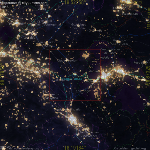
Analysis of Esperanza night lights 2016
Square area 10x10 km:
 0%
0%90-99
0.87%80-89
0%70-79
0%60-69
3.68%50-59
1.52%40-49
4.33%30-39
1.3%20-29
1.73%10-19
1.73%0-9
84.85%Square area 50x50 km:
0.12%90-99
0.28%80-89
0.62%70-79
1.21%60-69
2.43%50-59
1.15%40-49
2.25%30-39
1.51%20-29
1.65%10-19
6.48%0-9
82.29%Clear (daylight) street map image can be seen on geolist.org.
Map coordinates:
19° 31' 21.3" North, 98° 4' 46.3" West
18° 51' 30.7" North, 97° 22' 35.1" West
18° 11' 30.6" North, 96° 40' 23.8" West
Some cities around Esperanza sort by population:
• Río Blanco
23.4 km =14.5 mi,  97°
97°
• Ciudad Mendoza
21.6 km =13.4 mi,  105°
105°
• Ciudad Serdán
16.2 km =10.1 mi,  333°
333°
• Nogales
22.7 km =14.1 mi, 98°
• Maltrata
11.9 km =7.4 mi,  116°
116°
• Xaltepec
24.5 km =15.2 mi,  276°
276°
• Cuacnopalan
14.9 km =9.3 mi,  252°
252°
• Acultzingo
17.3 km =10.7 mi,  153°
153°
3527748 (p: 7,833)
Sources (retrieved 2019-11-25):
» Earth at Night: Flat Maps 2012, 2016