Santa Maria Coatepec night lights from space
Night Light of Santa Maria Coatepec (Puebla) from space (Mexico) Src. Average luminocity for 10x10km area is 7.8377% and for 50x50km: 11.5775%.
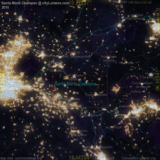
Analysis of Santa Maria Coatepec night lights 2016
Square area 10x10 km:
 0%
0%90-99
0%80-89
1.08%70-79
1.08%60-69
1.73%50-59
1.3%40-49
2.81%30-39
2.81%20-29
0%10-19
0%0-9
89.18%Square area 50x50 km:
0.14%90-99
0.51%80-89
2.21%70-79
1.93%60-69
2.44%50-59
1.35%40-49
3.33%30-39
2.58%20-29
2.71%10-19
6.49%0-9
76.31%Clear (daylight) street map image can be seen on geolist.org.
Map coordinates:
19° 46' 20.2" North, 98° 17' 44.4" West
19° 6' 33.3" North, 97° 35' 33.1" West
18° 26' 36.7" North, 96° 53' 21.9" West
Some cities around Santa Maria Coatepec sort by population:
• Ciudad Serdán
20.4 km =12.7 mi,  131°
131°
• San Salvador El Seco
5.8 km =3.6 mi,  297°
297°
• Palmarito Tochapan
23.6 km =14.7 mi,  191°
191°
• Quecholac
18.5 km =11.5 mi,  202°
202°
• Zacatepec
18.6 km =11.6 mi,  19°
19°
• Tlachichuca
18.2 km =11.3 mi,  88°
88°
• San Sebastián Villanueva
14.4 km =8.9 mi,  248°
248°
• Soltepec
12.3 km =7.6 mi,  276°
276°
3530532 (p: 5,524)
Sources (retrieved 2019-11-25):
» Earth at Night: Flat Maps 2012, 2016