Soltepec night lights from space
Night Light of Soltepec (Puebla) from space (Mexico) Src. Average luminocity for 10x10km area is 12.7403% and for 50x50km: 17.0745%.
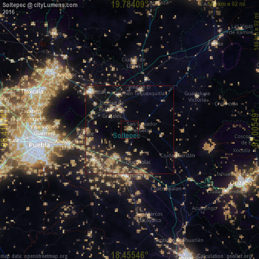
Analysis of Soltepec night lights 2016
Square area 10x10 km:
 0%
0%90-99
0%80-89
1.73%70-79
0.22%60-69
4.33%50-59
2.6%40-49
5.19%30-39
0.65%20-29
1.08%10-19
0.87%0-9
83.33%Square area 50x50 km:
0.26%90-99
0.88%80-89
3.43%70-79
2.73%60-69
3.39%50-59
1.89%40-49
4.74%30-39
4.01%20-29
4.59%10-19
11.65%0-9
62.43%Clear (daylight) street map image can be seen on geolist.org.
Map coordinates:
19° 47' 2.7" North, 98° 24' 42.3" West
19° 7' 16" North, 97° 42' 31" West
18° 27' 19.7" North, 97° 0' 19.8" West
Some cities around Soltepec sort by population:
• Acatzingo
17.4 km =10.8 mi,  207°
207°
• San Salvador El Seco
7.2 km =4.5 mi,  79°
79°
• Quecholac
19.2 km =11.9 mi,  164°
164°
• Grajales
15.5 km =9.6 mi,  320°
320°
• Santa María Ixtiyucán
13 km =8.1 mi,  304°
304°
• San Sebastián Villanueva
6.8 km =4.2 mi,  189°
189°
• Nopalucán
16.1 km =10 mi,  312°
312°
• Santa Maria Coatepec
12.3 km =7.6 mi,  96°
96°
3516552 (p: 6,547)
Sources (retrieved 2019-11-25):
» Earth at Night: Flat Maps 2012, 2016