Zacatepec night lights from space
Night Light of Zacatepec (Puebla) from space (Mexico) Src. Average luminocity for 10x10km area is 2.6494% and for 50x50km: 5.5609%.
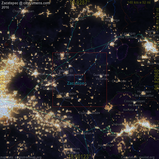
Analysis of Zacatepec night lights 2016
Square area 10x10 km:
 0%
0%90-99
0%80-89
0%70-79
0%60-69
1.3%50-59
0.87%40-49
1.73%30-39
0.87%20-29
0%10-19
0%0-9
95.24%Square area 50x50 km:
0.1%90-99
0.19%80-89
0.69%70-79
0.65%60-69
1.09%50-59
1%40-49
1.88%30-39
1.03%20-29
0.94%10-19
1.38%0-9
91.04%Clear (daylight) street map image can be seen on geolist.org.
Map coordinates:
19° 55' 43.3" North, 98° 14' 9.3" West
19° 15' 58.7" North, 97° 31' 58.1" West
18° 36' 4.4" North, 96° 49' 46.8" West
Some cities around Zacatepec sort by population:
• San Salvador El Seco
18.7 km =11.6 mi,  217°
217°
• Villa de El Carmen Tequexquitla
14.2 km =8.8 mi,  296°
296°
• Guadalupe Victoria
20.1 km =12.5 mi,  82°
82°
• Oriental
15.3 km =9.5 mi,  322°
322°
• Cuapiaxtla
25 km =15.5 mi,  277°
277°
• Tlachichuca
20.6 km =12.8 mi,  144°
144°
• Soltepec
24.5 km =15.2 mi,  228°
228°
• Santa Maria Coatepec
18.6 km =11.6 mi,  199°
199°
3514162 (p: 10,204)
Sources (retrieved 2019-11-25):
» Earth at Night: Flat Maps 2012, 2016