Quecholac night lights from space
Night Light of Quecholac (Puebla) from space (Mexico) Src. Average luminocity for 10x10km area is 24.3074% and for 50x50km: 16.8243%.
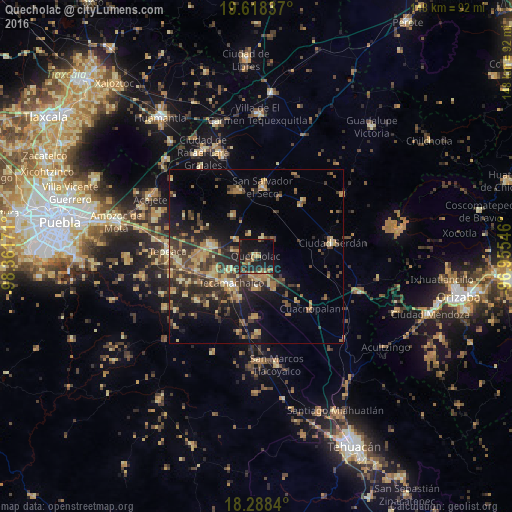
Analysis of Quecholac night lights 2016
Square area 10x10 km:
 0%
0%90-99
0.65%80-89
1.52%70-79
4.11%60-69
5.19%50-59
4.98%40-49
4.98%30-39
1.95%20-29
16.02%10-19
41.77%0-9
18.83%Square area 50x50 km:
0.12%90-99
0.58%80-89
3.22%70-79
2.54%60-69
3.88%50-59
1.98%40-49
4.59%30-39
4.79%20-29
5.21%10-19
10.09%0-9
62.99%Clear (daylight) street map image can be seen on geolist.org.
Map coordinates:
19° 37' 6.1" North, 98° 21' 42.2" West
18° 57' 17" North, 97° 39' 30.9" West
18° 17' 18.2" North, 96° 57' 19.7" West
Some cities around Quecholac sort by population:
• Tecamachalco
11.2 km =7 mi,  224°
224°
• Acatzingo
13.5 km =8.4 mi,  282°
282°
• Palmarito Tochapan
6.3 km =3.9 mi,  160°
160°
• Huixcolotla
12.5 km =7.8 mi,  252°
252°
• Tlaixpan
9.6 km =6 mi,  240°
240°
• Xaltepec
9.7 km =6 mi,  146°
146°
• Santiago Alseseca
13.2 km =8.2 mi,  202°
202°
• San Sebastián Villanueva
13.4 km =8.3 mi,  331°
331°
3520926 (p: 10,216)
Sources (retrieved 2019-11-25):
» Earth at Night: Flat Maps 2012, 2016