Tezontepec night lights from space
Night Light of Tezontepec (Hidalgo) from space (Mexico) Src. Average luminocity for 10x10km area is 21.9351% and for 50x50km: 35.953%.
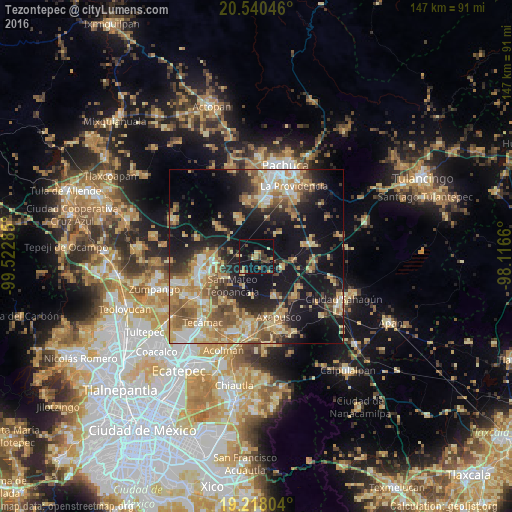
Analysis of Tezontepec night lights 2016
Square area 10x10 km:
 0%
0%90-99
0.43%80-89
4.11%70-79
4.11%60-69
3.46%50-59
0%40-49
7.58%30-39
3.9%20-29
4.98%10-19
34.2%0-9
37.23%Square area 50x50 km:
3.3%90-99
4.29%80-89
7.21%70-79
6.61%60-69
7.3%50-59
4.81%40-49
5.56%30-39
4.35%20-29
7.58%10-19
24.14%0-9
24.85%Clear (daylight) street map image can be seen on geolist.org.
Map coordinates:
20° 32' 25.7" North, 99° 31' 22.3" West
19° 52' 50.3" North, 98° 49' 11" West
19° 13' 4.9" North, 98° 6' 59.8" West
Some cities around Tezontepec sort by population:
• Don Antonio
12 km =7.5 mi,  266°
266°
• Acayuca
16.3 km =10.1 mi,  352°
352°
• Tolcayuca
13.5 km =8.4 mi,  309°
309°
• Zempoala
16.5 km =10.3 mi,  76°
76°
• Temascalapa
10.4 km =6.5 mi,  235°
235°
• Santa Ana Tlachiahualpa
15.6 km =9.7 mi,  216°
216°
• San Luis Tecuhautitlán
14.5 km =9 mi,  209°
209°
• Huitzila
16.2 km =10.1 mi, 241°
3515691 (p: 5,214)
Sources (retrieved 2019-11-25):
» Earth at Night: Flat Maps 2012, 2016