Santa Ana Tlachiahualpa night lights from space
Night Light of Santa Ana Tlachiahualpa (Hidalgo) from space (Mexico) Src. Average luminocity for 10x10km area is 51.7252% and for 50x50km: 51.1062%.
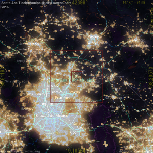
Analysis of Santa Ana Tlachiahualpa night lights 2016
Square area 10x10 km:
 0.41%
0.41%90-99
1.86%80-89
9.3%70-79
10.74%60-69
13.43%50-59
15.29%40-49
23.55%30-39
7.85%20-29
11.78%10-19
5.79%0-9
0%Square area 50x50 km:
8.87%90-99
7.87%80-89
11.09%70-79
10.66%60-69
8.63%50-59
5.26%40-49
5.48%30-39
3.74%20-29
7.38%10-19
19.96%0-9
11.05%Clear (daylight) street map image can be seen on geolist.org.
Map coordinates:
20° 25' 44.4" North, 99° 36' 43.1" West
19° 46' 7.3" North, 98° 54' 31.9" West
19° 6' 20.3" North, 98° 12' 20.6" West
Some cities around Santa Ana Tlachiahualpa sort by population:
• Teotihuacán de Arista
10.1 km =6.3 mi,  150°
150°
• Teotihuacán
10.2 km =6.3 mi, 150°
• Reyes Acozac
7.6 km =4.7 mi,  275°
275°
• Tecámac de Felipe Villanueva
8.8 km =5.5 mi,  225°
225°
• Tecámac
8.8 km =5.5 mi, 225°
• Temascalapa
6.6 km =4.1 mi,  6°
6°
• San Luis Tecuhautitlán
2.1 km =1.3 mi,  94°
94°
• Huitzila
6.8 km =4.2 mi,  313°
313°
3817790 (p: 5,781)
Sources (retrieved 2019-11-25):
» Earth at Night: Flat Maps 2012, 2016