Don Antonio night lights from space
Night Light of Don Antonio (Hidalgo) from space (Mexico) Src. Average luminocity for 10x10km area is 59.7121% and for 50x50km: 43.6324%.
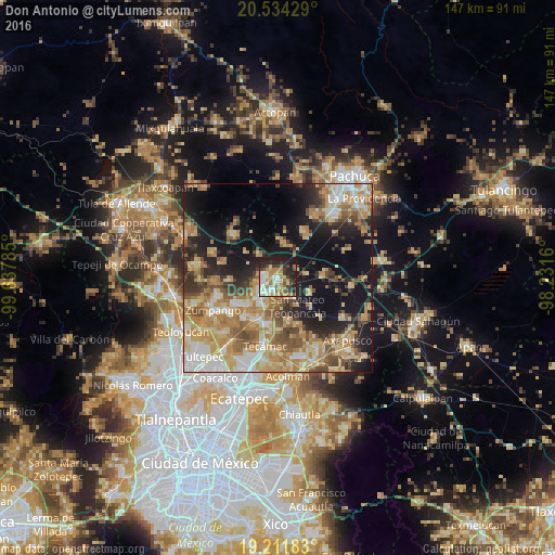
Analysis of Don Antonio night lights 2016
Square area 10x10 km:
 10.61%
90-99
13.42%80-89
8.01%70-79
10.39%60-69
12.99%50-59
2.81%40-49
6.06%30-39
9.09%20-29
18.61%10-19
8.01%0-9
0%Square area 50x50 km:
5.34%90-99
6.17%80-89
8.85%70-79
9.03%60-69
9.14%50-59
5.21%40-49
5.72%30-39
4.27%20-29
8.07%10-19
19.2%0-9
18.99%Clear (daylight) street map image can be seen on geolist.org.
Map coordinates:
20° 32' 3.4" North, 99° 38' 16.3" West
19° 52' 28" North, 98° 56' 5" West
19° 12' 42.6" North, 98° 13' 53.8" West
Some cities around Don Antonio sort by population:
• Tizayuca
6 km =3.7 mi,  226°
226°
• Reyes Acozac
12 km =7.5 mi,  203°
203°
• San Bartolo Cuautlalpan
10.3 km =6.4 mi, 230°
• San Francisco Zacacalco
7.9 km =4.9 mi,  320°
320°
• Tolcayuca
9.4 km =5.8 mi,  9°
9°
• Temascalapa
6.2 km =3.9 mi,  146°
146°
• Tezontepec
12 km =7.5 mi,  86°
86°
• Huitzila
7.4 km =4.6 mi, 197°
8858113 (p: 17,736)
Sources (retrieved 2019-11-25):
» Earth at Night: Flat Maps 2012, 2016