Zempoala night lights from space
Night Light of Zempoala (Hidalgo) from space (Mexico) Src. Average luminocity for 10x10km area is 24.4654% and for 50x50km: 26.6805%.
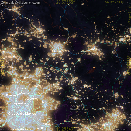
Analysis of Zempoala night lights 2016
Square area 10x10 km:
 0%
0%90-99
1.52%80-89
6.71%70-79
5.19%60-69
2.16%50-59
2.16%40-49
2.6%30-39
2.6%20-29
2.81%10-19
56.71%0-9
17.53%Square area 50x50 km:
2.02%90-99
2.38%80-89
5.47%70-79
4.48%60-69
4.54%50-59
2.77%40-49
4.59%30-39
4.25%20-29
7.26%10-19
24.67%0-9
37.57%Clear (daylight) street map image can be seen on geolist.org.
Map coordinates:
20° 34' 32" North, 99° 22' 8.9" West
19° 54' 57.1" North, 98° 39' 57.6" West
19° 15' 12.3" North, 97° 57' 46.4" West
Some cities around Zempoala sort by population:
• Ciudad Sahagun
18.3 km =11.4 mi,  148°
148°
• La Providencia Siglo XXI
17.3 km =10.7 mi,  342°
342°
• Tepeapulco
18.5 km =11.5 mi,  140°
140°
• Tlanalapa
12.6 km =7.8 mi, 149°
• Pachuquilla
17.5 km =10.9 mi,  349°
349°
• Tezontepec
16.5 km =10.3 mi,  256°
256°
• Los Tuzos
18 km =11.2 mi,  328°
328°
• Jaltepec
21 km =13 mi,  170°
170°
3514043 (p: 6,798)
Sources (retrieved 2019-11-25):
» Earth at Night: Flat Maps 2012, 2016