San Luis Tecuhautitlán night lights from space
Night Light of San Luis Tecuhautitlán (Hidalgo) from space (Mexico) Src. Average luminocity for 10x10km area is 45.3698% and for 50x50km: 48.8026%.
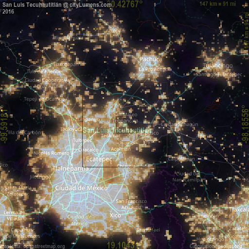
Analysis of San Luis Tecuhautitlán night lights 2016
Square area 10x10 km:
 0%
0%90-99
0.83%80-89
9.09%70-79
8.26%60-69
9.71%50-59
10.12%40-49
22.11%30-39
8.88%20-29
17.56%10-19
13.22%0-9
0.21%Square area 50x50 km:
8.03%90-99
7.2%80-89
10.64%70-79
10.3%60-69
8.46%50-59
5.11%40-49
5.21%30-39
3.7%20-29
7.23%10-19
21.03%0-9
13.09%Clear (daylight) street map image can be seen on geolist.org.
Map coordinates:
20° 25' 39.6" North, 99° 35' 30.5" West
19° 46' 2.5" North, 98° 53' 19.2" West
19° 6' 15.5" North, 98° 11' 8" West
Some cities around San Luis Tecuhautitlán sort by population:
• Teotihuacán de Arista
9.1 km =5.7 mi,  161°
161°
• Teotihuacán
9.2 km =5.7 mi, 161°
• Reyes Acozac
9.7 km =6 mi,  275°
275°
• Santa María Ajoloapan
7.4 km =4.6 mi,  266°
266°
• San Martín de las Pirámides
8.8 km =5.5 mi,  140°
140°
• Temascalapa
6.8 km =4.2 mi,  348°
348°
• Santa Ana Tlachiahualpa
2.1 km =1.3 mi, 274°
• Huitzila
8.6 km =5.3 mi,  304°
304°
3817791 (p: 5,694)
Sources (retrieved 2019-11-25):
» Earth at Night: Flat Maps 2012, 2016