Temascalapa night lights from space
Night Light of Temascalapa (México) from space (Mexico) Src. Average luminocity for 10x10km area is 43.9892% and for 50x50km: 44.5976%.
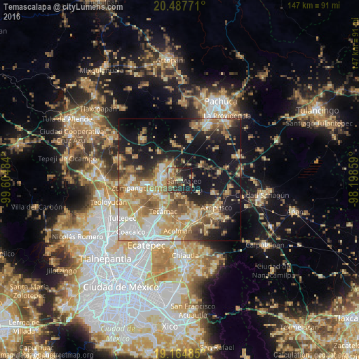
Analysis of Temascalapa night lights 2016
Square area 10x10 km:
 2.16%
2.16%90-99
2.81%80-89
9.09%70-79
6.28%60-69
9.96%50-59
8.87%40-49
9.09%30-39
9.96%20-29
17.97%10-19
23.81%0-9
0%Square area 50x50 km:
6.45%90-99
6.12%80-89
8.79%70-79
8.95%60-69
8.59%50-59
5.53%40-49
5.86%30-39
3.97%20-29
7.74%10-19
21.48%0-9
16.52%Clear (daylight) street map image can be seen on geolist.org.
Map coordinates:
20° 29' 15.8" North, 99° 36' 17.4" West
19° 49' 39.6" North, 98° 54' 6.2" West
19° 9' 53.5" North, 98° 11' 54.9" West
Some cities around Temascalapa sort by population:
• Tizayuca
7.8 km =4.8 mi,  277°
277°
• Reyes Acozac
10.1 km =6.3 mi,  234°
234°
• Santa María Ajoloapan
9.3 km =5.8 mi,  220°
220°
• Don Antonio
6.2 km =3.9 mi,  326°
326°
• Santa Ana Tlachiahualpa
6.6 km =4.1 mi,  186°
186°
• San Luis Tecuhautitlán
6.8 km =4.2 mi,  168°
168°
• Tezontepec
10.4 km =6.5 mi,  55°
55°
• Huitzila
5.9 km =3.7 mi,  252°
252°
3516050 (p: 6,314)
Sources (retrieved 2019-11-25):
» Earth at Night: Flat Maps 2012, 2016