Huitzila night lights from space
Night Light of Huitzila (Hidalgo) from space (Mexico) Src. Average luminocity for 10x10km area is 72.3967% and for 50x50km: 51.4618%.
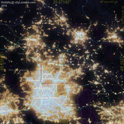
Analysis of Huitzila night lights 2016
Square area 10x10 km:
 10.74%
90-99
15.7%80-89
12.6%70-79
14.88%60-69
17.56%50-59
13.43%40-49
9.71%30-39
4.55%20-29
0.83%10-19
0%0-9
0%Square area 50x50 km:
9.35%90-99
8.1%80-89
10.1%70-79
9.97%60-69
9.18%50-59
5.66%40-49
6.08%30-39
4.67%20-29
8.59%10-19
16.25%0-9
12.05%Clear (daylight) street map image can be seen on geolist.org.
Map coordinates:
20° 28' 17.4" North, 99° 39' 32.3" West
19° 48' 40.9" North, 98° 57' 21" West
19° 8' 54.6" North, 98° 15' 9.8" West
Some cities around Huitzila sort by population:
• Tizayuca
3.6 km =2.2 mi,  323°
323°
• Reyes Acozac
4.8 km =3 mi,  213°
213°
• Santa María Ajoloapan
5.3 km =3.3 mi,  183°
183°
• Don Antonio
7.4 km =4.6 mi,  17°
17°
• San Bartolo Cuautlalpan
5.7 km =3.5 mi,  274°
274°
• Paseos de San Juan
7.2 km =4.5 mi,  243°
243°
• Temascalapa
5.9 km =3.7 mi,  72°
72°
• Santa Ana Tlachiahualpa
6.8 km =4.2 mi,  133°
133°
3526884 (p: 5,151)
Sources (retrieved 2019-11-25):
» Earth at Night: Flat Maps 2012, 2016